Parish: Wollongong
County: Camden
Keiraville is a short distance north west of the Wollongong city centre, at the foot of the Illawarra escarpment. It is home to Wollongong Botanic Garden and the University of Wollongong.
Local communities of Aboriginal people were the original inhabitants and Traditional Custodians of Illawarra Land. Their dialect is a variant of the Dharawal language.
Before European settlement, the Aboriginal people of the region lived in small family groups with complicated social structures and close associations with specific areas.
Suburb boundaries do not reflect the cultural boundaries of the local Aboriginal community.
Traditional Custodians today are descendants of the original inhabitants and have ongoing spiritual and cultural ties to the Land and waterways where their ancestors lived.
Keiraville is situated on part of the two 1,000 acre grants originally promised to James Stares Spearing by Governor Brisbane in 1825. These properties were known as Paulsgrove.
In 1835 Spearing sold Paulsgrove to Colonel John Thomas Leahy who changed the name to ‘Mount Keera’ Estate. The grants were finally issued in 1841 to Robert and Charles Campbell.
Keiraville seems to have been founded as a village about 1880. On the 15 June 1886 the Illawarra Mercury refers to Keiraville as “one of the new localities that have sprung into existence of late years”.
The names “Village of Keira” and “Keira Village” also seem to have been used. A notice from the Land Titles Office, dated 17 June 1890 refers to it as the “Village of Keira”.
Keira is an Aboriginal name meaning large lagoon or high mountain. Local Aboriginal people called the mountain "Djera" meaning wild turkey (Wollongong City Council, 1995).
James Stares Spearing
The 1828 census shows that James Stares Spearing "came free" to Australia on the ship Harvey in 1825. He was aged about 47 years old.
On his arrival in Australia, Spearing was promised two 1,000 acre grants from Governor Brisbane. The first grant extended roughly from Foley's Road to half way up Mount Keira, and from the Technical College in Lysaght Street, North Wollongong to Wisemans Park. The adjoining portion extended from Cross Roads to Mount Keira township and south almost to Figtree Hotel (McDonald, 1988).
Upon taking possession of the land James Spearing named the estate 'Paulsgrove'. He built a home near the north-western end of Yellagong Street, West Wollongong and by late 1826 he was well established (McDonald, 1988).
Spearing cultivated a successful 15 acre farm and orchard. The Para Creek ran through 'Paulsgrove' which was later named 'Mount Keira Estate' (Lindsay, 1994, Cousins 1994).
The 1828 census credited Spearing with 400 acres cleared and 250 acres cultivated, five horses and 50 horned cattle. He also had a flock of 750 sheep, the only flock in the district.
In the 1832 Australian Almanac, Spearing was noted as being the "principal agriculturalist of the district” with a garden well stocked with fruit trees and vegetables, two water mills and a windmill and convicts assigned to him to undertake manual work on the property (Paulsgrove Diary, 1988).
James Spearing left the Illawarra in 1835 and the 'Paulsgrove' properties were conveyed to Lt. Col. John Thomas Leahy who changed the name to 'Mount Keera'.
The grants for the property were finally issued in 1841 to Robert and Charles Campbell, who subdivided the estate into varying sized allotments ranging in size from 10 to 20 acres. The average price paid for the land was four pounds per acre.
Some of the people who purchased land from the sale were Denis Foley, John Gwynne, Denis Williams. Percy Young, William Northfield, John Stewart, William Robson, John Gilmore, Hugh Higgins and Ignacy Zlotkowski. The Keiraville village developed on the land that was purchased by William Robson (Booth & Johnson (ed), 1991, p.1-5).
Zlotkowski Estate
Ignacy Zlotkowski was one of the people who purchased land from Robert and Charles Campbell. Known as Zlotkowski Estate, the land comprised 48 acres and in 1856 was bounded by Mr Keira Road, Armstrong Street, Keira Mine Road and Robsons Road.
Zlotkowski was a professor of languages who fled from Poland in 1853 to escape the Crimean War. He became well known in Wollongong as chairman of the Wollongong National School Board and his wife also became involved with the school. The couple later moved to Sydney and the estate was sold in 1887 and subdivided with streets named after Wollongong Council alderman Poulter, Armstrong, Cochrane, Parsons and Robson (Booth & Johnson (ed), 1991, p.1).
James Shoobert
James Shoobert was a pioneer in coal mining at Mount Keira. He was a retired sea captain and a Justice of the Peace who also discharged public duties as a Magistrate. He opened two tunnels on the slopes of Mount Keira a short distance below the mine and named them 'Albert'.
On 27 August 1849 the first load of coal was transported down from Mount Keira to Wollongong in horse drawn coal carts. "The coal carts formed part of a procession led by a band and followed by horsemen. The procession also included the owner James Shoobert, miners and a large gathering of townspeople." (Spires 1990, p.1).
The first shipment of coal was in the steamer 'William the Fourth' and it soon found a market with the millers and manufacturers of Sydney.
The Shipp family
William Shipp arrived in Australia with his brother in about 1851. The Shipp family established a connection with the area through their residence at Mount Keira at a time when "all the area west of Wollongong was known as Mt Keira" (Organ & Doyle, 1989, p81).
William Shipp worked for a while in the Wollongong area, before settling with his family in Keiraville area. He became associated with the Mount Keira Colliery when he helped build the rail incline down to the harbour. He also assisted with the braking of the wagons down that incline.
His brother Thomas came to the area later and also worked in the colliery as a carpenter (Organ & Doyle, 1989, p. 81).
Dobing’s Bush
Dobing’s Bush was a large area of bush owned by John Dobing who came out from England in 1888 to work at Mt Keira Mine. Dobing’s land was bound by William Street to the west and eastwards including Akuna Street and Nyrang Park, Gipps Road, the Mt Keira Mine railways, William Street and Foley’s Road ((Booth & Johnson (ed), 1991, p. 5-7).
John Dobing and his wife Elizabeth had several children who attended Keiraville Public School and then went on to work at Mt Keira Mine. In 1901 John Dobing gave permission for Keiraville Public School to hold its Annual Picnic at Keira Park (later named Wiseman’s Park) where “athletic events” and novelty activities were held (Illawarra Mercury, 1901). In 1912, 22 acres of this land was sold for 600 pounds for recreational purposes and Wiseman’s Park was proclaimed in January 1913 and further subdivided in 1938.
Agriculture
The publication of the 'Paulsgrove Diary' illustrates the development of the early agricultural industry at Mount Keira and surrounding foothills. It was written by an overseer for Mr Spearing who was living at 'Paulsgrove' in 1833.
Spearing reportedly had a beautiful garden well stocked with fruit trees and vegetables, two water mills and a windmill. By 1830 he had up to 61 convicts assigned to him, who performed most of the manual work on the property (Paulsgrove Diary, 1988).
"The diary shows the acreage to have been, in 1833 and 1834, about 40 acres. The hillside at Mount Keira had fields of wheat, maize, barley, oats, rye, rape, turnips, onions, potatoes, peas and tobacco. There was also a well kept orchard containing peach, apricot, nectarine, plum and pear trees, as well as grape vines. There was also a large pig run. There were two watermills on Para Creek, running through the property. These were later replaced by a windmill." (Cousins 1994, p. 87).
Daily tasks included ploughing the fields, sowing, reaping, grinding the grain at the watermill, pulling out stumps, cross burning, and burning off generally. They also drove sheep and cattle. There was also a blacksmith, a shoemaker and a tailor on the estate.
Mr Spearing sent quantities of wheat, pork, maize, potatoes and whale oil to Sydney. The shipping was done by two 14 tonners, the 'Bee' and the 'Sarah', sometimes from Wollongong, sometimes from Bellambi. There were no stores in the Illawarra at the time so the captains of the trading ships acted as agents buying supplies in Sydney for Illawarra settlers (Cousins, 1994).
Spearing was an important early agriculturalist in the area. After the subdivision of his land the area continued to be used for agricultural purposes. A number of small farms used the land for grazing and producing different items ranging from oats, barley, maize and potatoes to fruit and other crops (Yewen, 2004, p.551-552).
Later, the area became noted for its association with the Mount Keira Colliery and the Hoskins-Australian Iron and Steel Works. The tram line which conveyed coal to the harbour passed directly through Keiraville and Gwynneville, and many locals were involved in the operation, upkeep and maintenance of the line (Raxworthy, Oral history; 1860, 1888; November-December 2000, p. 84-91).
Coal Mining
James Shoobert opened Mount Keira mine on 27 August 1849 with the first load of coal transported down from Mount Keira to Wollongong in horse drawn coal carts. In September 1855 he opened two tunnels on the slopes of Mount Keira a short distance below the mine (Booth & Johnson (ed), 1991, p.13).
The Osborne Wallsend Colliery (Kemira Colliery) was opened in 1857 by William Robson for its owner Henry Osborne. The mine worked the Bulli Seam for the first time on record.
On 16 April 1857, 3.5 tons of Keira coal was carted to the wharf at Belmore Basin by bullock team, to be transported to Sydney in the S.S. Illawarra. The Illawarra Mercury recorded the event as follows: "We have much pleasure in recording the perfect success of the trial of the new coal from the mine at Mount Keira, henceforth we understand to be called 'Osborne Wallsend'" (Spires, 1990).
The management of the mine was happy with its prospects and in May an advertisement in the Illawarra Mercury appeared asking for 20 teams to convey coal from the mine to the wharf at 6/- per ton. By September the coal mine was in operation and 150 tons had been consumed in Wollongong alone. Also 60 tons a week was used by the steamers and a considerable quantity was sent to Sydney. Keira coal gained a reputation for being superior to any other coal (Cousins, 1994).
During the early years of mining at Mount Keira the coal was delivered to the wharf by bullock teams hauling it down the steep Mount Keira track and old road. As the mine progressed a Main and Tail Rope Haulage installation brought coal to the surface and this early development included a skip incline. Henry Osborne, noting that hauling coal by bullock dray to the wharf was less than efficient, petitioned the Government to be allowed to build a tramway from the mine to the harbour.
Upon Henry Osborne's death in 1859, the Osborne Wallsend Coal Company was formed. Members of the company were William Robson, William Jackson, John Nixon and Andrew Tulip. The company owned two steamers, the 'Kurrara' and the 'Kanabooka' and the company was formed after arranging a 25-year lease from the Osbornes.
In 1867, Tulip, Nixon and Jackson sold their interest in Osborne Wallsend Colliery to Robson and Spiers. Four years later Robson and Spiers retired and the mine reverted back to the Osborne family. The Osborne's further developed the mine and also built several coke ovens producing coke using slack from the colliery.
In the 1870s the reputation of the Mount Keira coal was spreading and large shipments were made from Sydney to India, China and other parts of Asia. In 1833 a new ventilation shaft was sunk.
During the 1870s and 1880s work at the mine was irregular and flags were raised at Flagstaff Point and Flagstaff Hill when colliers arrived to call the miners to work. "Under these conditions overall growth of output was slow and at the turn of the century the area still had a general rural atmosphere. Most of the mineworkers were local born and part time farmers. A coal boom in the late eighties saw men brought in from European countries, and houses were built adjacent to the mine so that these people could be housed." (Spires, 1990).
Mount Keira Road
In April 1834 the Governor, Major-General Sir Richard Bourke, visited the Illawarra in reply to a petition presented to him by a number of residents asking for roads and safe harbours in the district. Surveyor General Mitchell was tasked with following the Major-General's instructions to open the district by road and improve its access to the Sydney market.
As a result, Mitchell planned Mount Keira Road, which partially followed O'Brien's Road but provided an easier descent into the district by way of Mount Keira, coming out at West Wollongong at the cross roads.
In 1834 Mitchell wrote to the Colonial Secretary "Mt Keera is the hill behind Mr Spearing's land, and the situation being almost desirable for a passage to the Illawarra both with respect to that of most of the farms and Sydney and also Wollongong. I examined the ground, and although it is covered with thick bush I succeeded in marking a line by which an easy and immediate ascent may be made without much labour, there being little rock in the way." (Marshall 1963, p.7).
This road was laid out in 1835-1836 by convict labour and followed the present Mount Keira Road and remained the main approach to the coast for years.
The Tramway
Meanwhile Henry Osborne petitioned the Government to be allowed to build a tramway from the mine to the harbour. He was allowed to build part of it but the tramway terminated twelve chains west of the heart of the Princes Highway. Another petition was made by the Osborne Wallsend Coal Company to extend the tramway to the Belmore Basin. The petition was granted and an Act of Parliament cited.
The tramroad was opened in May 1861 and "commenced at the foot of the incline, extending over and through lands of the late Henry Osborne passing under a reserved road near Macquarie Street, leading through the Mount Keira estate, and through the lands of Andrew Thompson and extending through land known as "Bustle Farm"…..and terminating at a point four chains and fifty links north-west of the north-west corner of Harbour Street. Thousands of tons of coal was hauled along this tramroad to the wharf at Belmore Basin by horse teams." (Spires 1990, p.7).
In 1878 the horse teams used for hauling coal along the tramroad to the wharf were replaced by steam locomotives. These locomotives, the Keira No.1 and Keira No. 2. were the first locomotives to work on the South Coast. They were ordered by Frank Osborne and shipped in 1878. They ran for eight years before the New South Wales Government Railway between Sydney and Wollongong was opened. The locomotives ceased running in 1954 when the line was closed (Spires, 1990).
In the 1860s, the Illawarra district was re-zoned into municipal government areas. At this time there were some important roads of considerable length which linked east and west in the district, including Foleys Road, Murphys Lane and Northfields Lane (Organ & Doyle, 1989, p. 62).
By the 1920s, Gipps Road had been established and a 1920s map notes that it was 66 feet wide (W.J Robinson's 2nd subdivision [map], 1927). By 1934 this road was constructed of bitumen, and was the main road linking the Princes Highway and Keira Village (Keiraville) (Illawarra Mercury, 9 February 1934).
Keiraville buses
In 1947, former timber industrialist Neil Watt, and engineer Jim Peniston, decided to start a bus transport business, trading under the name Watt and Peniston. The men purchased a portion of a bus run previously owned by a local family business Rutty's Bus Services. The bus depot was located in Gipps Road Keiraville and included both petrol-driven buses and a 44-passenger diesel bus.
The Illawarra Mercury reported in June 1951 that “Transport officials in Sydney have stated that the buses owned by Watt and Peniston are among the best kept on the South Coast” (South Coast Times, 11 Jun 1951). The original bus routes were Keiraville-Wollongong, Gwynneville-Wollongong and Mt Pleasant-Wollongong. There was also a Worker’s service Keiraville to Port Kembla via Figtree and Unanderra and a Miner’s run from Gwynneville to Mt Keira Colliery (South Coast Times, 11 June 1951).
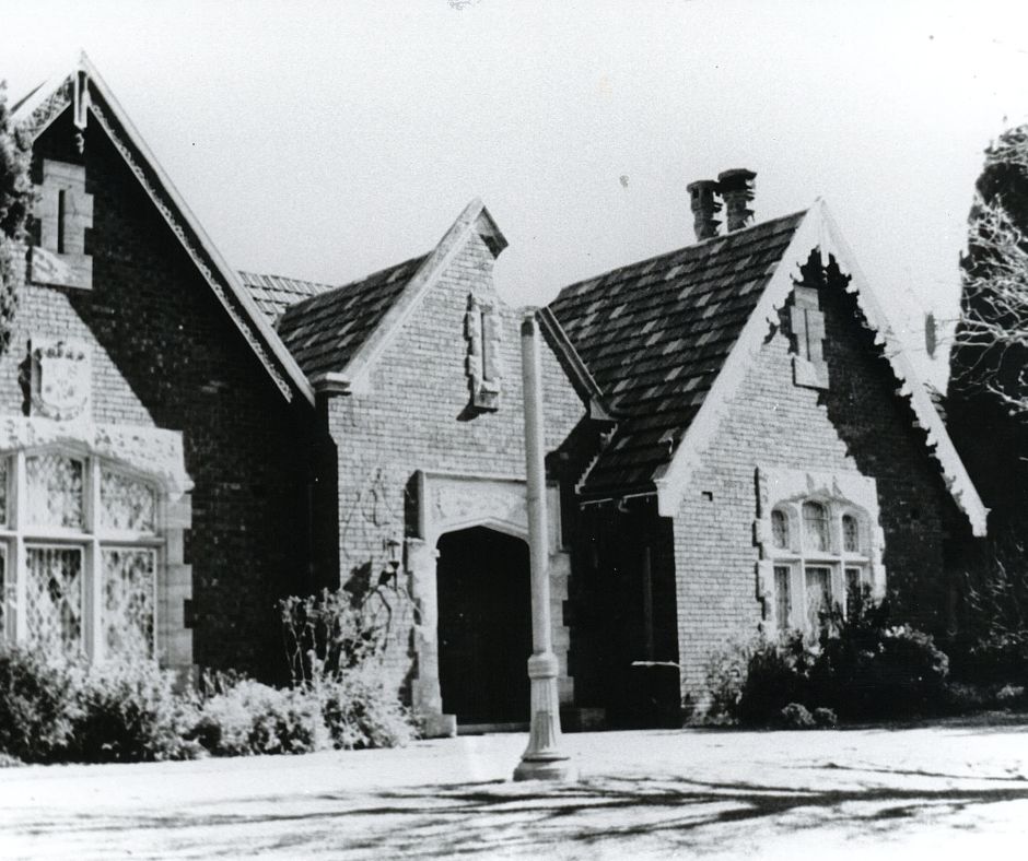
Gleniffer Brae Manor House
Address: Murphys Avenue, Keiraville
After Robert and Charles Campbell subdivided Paulsgrove Estate and the area became known as Mount Keera Estate, three blocks of land were purchased by John Kenny in 1855, with the land then bought by Matthew Hannan 1865. In 1901 James Fitzgerald acquired the land and it became a dairy farm where he built Cratloe Cottage which still stands within the Wollongong Botanic Garden grounds.
In 1929 Arthur Sidney (Sid) Hoskins purchased 75 acres of the land and in 1937 Cratloe Cottage was given to Hoskin’s gardener Eric Winter. The Hoskins family are synonymous with the development of Australia’s steel industry, establishing Australian Iron and Steel Ltd in Port Kembla. In 1939 Hoskins and his wife Helen (Madge) completed building their family home Gleniffer Brae Manor on the hill overlooking the gardens and Cratloe Cottage (Buck, 2011, p.10.).
Mrs Hoskin’s brother, architect Geoffrey Loveridge, was commissioned to design Gleniffer Brae with landscape designer Paul Sorensen employed to design the gardens. The design of the house is Tudor Manor style adapted for domestic construction. The building features roof gables decorated with elaborately designed brick filling, carved and moulded stonework and lead light windows featuring colourful figures (Buck, 2011, p. 20-22). The name Gleniffer Brae came from Madge’s grandfather’s house, near Bowral, which was also called Gleniffer Brae. The name originally came from a range of hills in Paisley, Scotland where he was born
In 1951 the Hoskins family donated 46 acres of the estate to Wollongong City Council for the purpose of building a Botanic Garden.
In 1954 Gleniffer Brae and the surrounding 15.5 acres was purchased by the Sydney Church of England Girls Grammar School (SCEGGS) to operate a Wollongong campus. A year later they purchased a further 20 acres from Wollongong City Council to increase the size of the school (Buck, 2011, p. 27).
In 1975 SCEGGS merged with The Illawarra Grammar School at its Mangerton campus. In 1980, after SCEGGS had closed, Wollongong City Council leased the school buildings and some rooms within the manor house to the Wollongong Branch of the NSW Conservatorium of Music, which took up residence on part of the site. Council used the remainder of the house as a function centre until 2009 (Buck, 2011, p.77, 83).
In 1985 Gleniffer Brae Manor House was listed on the National Trust of Australia Register. In 1999 Gleniffer Brae Manor House was added the NSW State Heritage Register and is now protected under the NSW Heritage Act. (Wollongong Botanic Garden website).
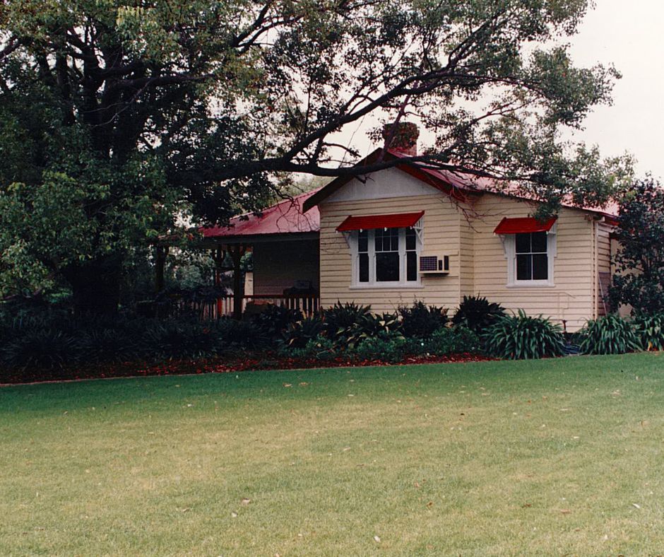
Cratloe Cottage (Botanic Gardens Education Centre)
Address: Madoline Street entrance – Wollongong Botanic Garden, Keiraville
In 1855 John Kenny purchased three blocks of land within the Mount ‘Keera’ Estate and in 1865 the land was bought by Matthew Hannan. James Fitzgerald then acquired the land in 1901 which became a working dairy farm. In 1921 Fitzgerald built a house and named it Cratloe Cottage. Later that year the land was sold to Mary Anne and Keith Blow, who shortly afterward sold it again to Harman Turner Johnson.
In 1929 Arthur Sidney Hoskins purchased 75 acres of land and in 1937 Cratloe Cottage was given to Hoskin’s gardener Eric Winter.
In 1939 Hoskins completed building his family home Gleniffer Brae Manor on the hill overlooking the Botanic Garden. In 1951 Hoskins donated 46 acres of the estate to Wollongong City Council for the purpose of building a Botanic Garden.
In 1966 Wollongong City Council purchased Cratloe Cottage and the adjoining 2.5 acres. In January 1971 Wollongong Botanic Garden was officially opened to the public. Cratloe Cottage became the home of the Botanic Garden Curator until 1978.
Despite its many owners, Cratloe Cottage still stands within Wollongong Botanic Garden and is used as an environmental education centre for students and visitors. (Wollongong Botanic Garden website).
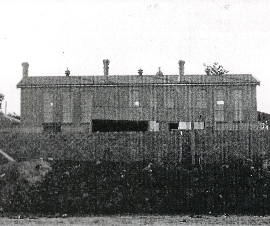
Keiraville Public School and Headmaster’s Residence c1891
Address: 286 Gipps Road, Keiraville. Headmaster’s residence was on Grey Street, Keiraville to the north of the school.
In 1890 the population of Keiraville had reached 250 with about 100 children travelling several miles to attend either Wollongong or Mount Keira schools. The community petitioned the Minister for Public Instruction for a local school and with support from the Member for Illawarra, the Government Medical Officer and other community members the request was granted on 17 July 1890 (Booth & Johnson (ed), 1991, p. 31-32).
The site suggested by parents was the corner of Grey Street and Gipps Road which was part of James Spearing’s original grants made in the 1820’s. It was decided the Department’s stock plan “D” buildings would be constructed to accommodate 100 children. This was a brick building containing a schoolroom 25ft by 19ft and a classroom 15ft by 19ft, plus a combined lobby, hat room and washing facilities running the length of the building (Booth & Johnson (ed), 1991, p. 32).
A teacher’s residence was also to be constructed just north of the school building (up the hill) consisting of five bedrooms plus a detached kitchen, bathroom and wash-house.
Classes at Keiraville Public School officially began on 7 September 1891. Fifty-six boys and 62 girls were enrolled. The school was officially opened on Monday 9 November with a public picnic. The first headmaster was William Johnson who had begun his teaching career as a 16-year-old pupil teacher at Wollongong Public School in 1881. He was assisted by pupil teacher Samuel Shipp who lived in Keiraville and had begun working as a 15-year-old pupil teacher at Mount Keira in January 1891 (Booth & Johnson (ed), 1991, p. 33).
In 1893 parents signed a petition asking for a weathershed to be erected and in 1894 a double weathershed was built at a cost of thirty-five pounds, enabling the boys and girls to be separated during play time (Booth & Johnson (ed), 1991, p. 33).
With fears of a Japanese attack on Wollongong and Port Kembla during WW2, precautionary measures were put in place in 1942 to protect school children. At Keiraville Public School, 120 feet of trenches, six feet deep and two and a half feet wide were dug by volunteers (Booth & Johnson (ed), 1991, p. 37).
In 1991 the school celebrated its Centenary with a series of formal and informal events and publication of a Centenary Book.
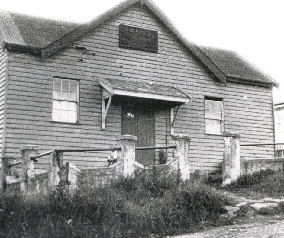
Mechanics’ Institute (School of Arts)
Address: Corner of Bell and Rose Streets, Keiraville
In June 1899 work began on the foundations for the Keiraville Mechanic’s Institute or School of Arts on the corner of Bell and Rose Streets. The hall was 20ft by 40 ft and was officially opened by the Deputy Chief Inspector of Schools on 23 September 1899.
The Institute was a wooden building with a dance floor and stage. There was an entrance door and porch and two rooms in the front. The walls were decorated with shields including an Honour Roll after World War One. The hall served the whole community and was used for Sunday school, weddings, Christmas plays, local meetings, Infants school classes, fundraising concerts, ambulance classes for miners, family evenings, temperance meetings and air raid warden training.
The Institute was also used as a men’s club with a billiard room and library for use by men only.
The Institute was run by a committee of local residents until it was demolished in the 1970’s to make way for a women’s refuge (Booth & Johnson (ed), 1991, p. 19-20).
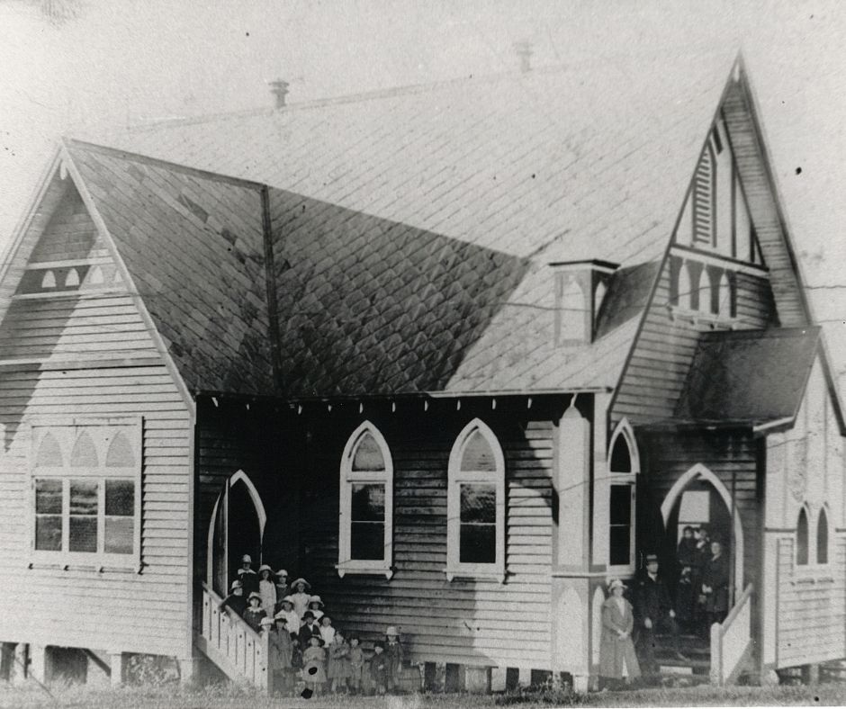
St John’s Church of England, Keiraville (now Keiraville International Church)
Address: 16-18 Eastern St, Gwynneville
The first Church of England building in Keiraville was erected in Parson’s Street on the Zlotskowski Estate and opened in August 1906. In an article published in the Illawarra Mercury on 28 August 1906, St John’s Church building was described as “measuring 38 feet by 20 feet and is constructed of stud and weatherboard on a stone foundation. It has been erected on a commanding site and is a distinct ornament to the locality. The Keiraville people are to be heartily congratulated upon the success of their undertaking.” (Local Cuttings file)
In 1940 the church building was damaged beyond repair during a severe wind storm. Church members salvaged some of the furnishings from the old building with the communion rails used in the new church built a year later in 1941. The new church building was opened and dedicated on 25 October 1941 without a roof as money and materials were limited due to World War Two (Local Cuttings file).
In 1969 St John’s was made a provisional parish and the Parish Council pushed for construction of a new building. Construction began in August 1972 at the new location of Eastern Street on the border of Keiraville and Gwynneville. The first service in the new church building was held in February 1973 (Local Cuttings file).
In 1912 a Methodist Church was operating in William Street Keiraville after previously operating out of the Keiraville Mechanics Institute (Booth & Johnson (ed), 1991, p. 21).
The Keiraville Congregational Church situated at the corner of Gipps Road and Grey Street, opposite Keiraville Public School, held services until around 1938 (Booth & Johnson (ed), 1991, p. 22).
University of Wollongong
The University of Wollongong was founded in 1951 as the Wollongong Division of the New South Wales University of Technology. In 1961 the division became the Wollongong College of the University of New South Wales, officially opening in 1962.
In 1961 the Orange Grove farmhouse situated on farmland on Northfields Avenue that had been part of the original Paulsgrove Estate, was demolished and surrounding cow paddocks were cleared in readiness to became the site of the new college (Castle, 1991).
In January 1975, NSW Parliament incorporated the University of Wollongong (UOW) as an independent higher learning institution consisting of five faculties - including engineering, humanities, mathematics, sciences and social sciences with Michael Birt appointed as its inaugural vice chancellor (Castle, 1991).
In 1982, UOW amalgamated with the Wollongong Institute of Higher Education which had begun life in 1962 as the Wollongong Teachers' College, resulting in the rapid growth of the university throughout the 1980s.
Keiraville is mostly a residential suburb of Wollongong but it is dominated by in the north by the expansive Wollongong Botanic Garden and the main University of Wollongong campus located at the foothills of Mount Keira. Only the steeper escarpment land is not developed.
Mount Keira is 469 metres above sea level and is part of the Illawarra Escarpment. Mount Keira provides an impressive backdrop to the City of Wollongong. The vegetation is made up of a mixture of rainforest and sclerophyll forest. Early logging removed most of the oldest and largest tall forest trees in the area but there is a stand of Turpentines "as tall as sixty metres and over two metres in diameter" near Mount Keira (Cox & Outteridge, 1990; Environment Illawarra, 1992).
Mount Keira and the Illawarra are important phyto-geographical areas. Mount Keira is a crossover point, with many species reaching their northern and southern limits within the area. Those at their northern limits are temperate species such as the eucalypts Yellow Stringybard (Eucalyptus muellerana) and Gully Gum (Eucalyptus smithii). Subtropical species such as White Bolly Gym, (Neolitsea dealbata) and Red Kamala (Mallotus philippensis) can be found in the rainforest of the lower foothills of Mount Keira. (Cox & Outteridge, 1990; Environment Illawarra, 1992).
The escarpment forests provide a habitat for a large number of fauna species, some of which are rare and endangered. In the Cox and Outteridge survey of Mount Keira Summit Park only two species of small mammals were caught. These were Antechinus stuartii and Rattus fuscipes. One Brush Tailed Possum (Trichsurus vulpecular) was spotted and numerous scats and diggings from the long nosed bandicoot were identified.
A total of 26 bird species were also identified in this survey, in a four hour bird watching session. Lyrebird scratchings were found over the entire park indicating a large population of Lyrebirds (Cox & Outteridge, 1990; Environment Illawarra, 1992).
| Date | Event |
|---|---|
| 1891 | Keiraville Public School opened (Illawarra Index) |
| 1899 | Keiraville School of Arts officially opened (Illawarra Index) |
| 1899 | Keiraville Mechanic's Institute established on corner of Bell and Rose Streets (Local cuttings file) |
| 1906 | Episcopalian Church opened (Illawarra Index) |
| 1906 | St John's Anglican Church in Parsons Street was opened and dedicated in August as a branch Church of St Michael's, Wollongong (Local cuttings file) |
| 1928 | Mr and Mrs Hoskins purchased 75 acres of dairy farming land on which Gleniffer Brae was later built (Local cuttings file) |
| 1938-1939 | Gleniffer Brae built for Arthur Sidney Hoskins (Local cuttings file) |
| 1951 | University of Wollongong was established as a division of the then New South Wales University of Technology. In 1961, the division became the Wollongong College of the University of New South Wales. |
| 1954 | Hoskins Family donated 10.5 acres of land for the creation of a Botanical Garden (Local cuttings file) |
| 1954 | Hoskins sold Gleniffer Brae and a portion of land to the Anglican private girls school, SCEGGS (Local cuttings file) |
| 1955 | Sydney Church of England Grammar School for Girls at Glennifer Brae opened (Illawarra Index) |
| 1960 | New Keiraville Congregational Church held first service (Illawara Index) |
| 1962 | Botanic Garden planned on 25 acre site (Illawarra Index) |
| 1962 | Barnardo Home for boys and girls opened in Hillview Avenue (Illawarra Index) |
| 1963 | Final landscape plan for Botanic Garden adopted by Council (Local cuttings file) |
| 1964 | First tree planted in the Botanic Garden by curator, Bill Mearns (Local cuttings file) |
| 1966 | Keiraville Public School 75th Anniversary celebrations (Illawarra Index) |
| 1969 | Sir Roden and Lady Cutler planted a rare Dawn Redwood tree in the Botanic Garden (Illawarra Index) |
| 1970 | Council resolved that the Wollongong War Memorial Park be named 'Hoskins Park - Wollongong Botanic Garden' (Local cuttings file) |
| 1970 | Wollongong Botanic Garden was officially opened by Mrs A Hoskins and Lord Mayor Alderman E Ford (Local cuttings file) |
| 1975 | Dr Barnardo's Boy's Home closes due to lack of demand (Illawarra Index) |
| 1975 | The University of Wollongong was established as an independent higher learning institution. |
| 1976 | Wollongong City Council to extend the Botanic Garden by buying 6.9 hectares of land from SCEGGS (Illawarra Index) |
| 1977 | Gleniffer Brae property acquired by Wollongong City Council, subject to a covenant restricting its use to education (Local cuttings file) |
| 1978 | Wollongong City Council plan to acquire the SCEGGS Glennifer Brae property (Illawarra Index) |
| 1978 | Wollongong City Council took possession of the SCEGGS Glennifer Brae property after a four month dispute over its ownership (Illwarra Index) |
| 1979 | Conservatorium of Music, Council for Performing Arts and Pan Pacific Music Camps all have access to Gleniffer Brae (Illawarra Index) |
| 1982 | Tree planting ceremony in the 'Youth Forest', Richardson Park, Grey Street during the Australian Year of the Tree and World Environment Day (Local cuttings file) |
| 1988 | The equatorial sundial built after a design by Henry Moore was placed into the Rose Garden by Friends of the Botanic Garden (Local cuttings file) |
| 1990 | Centenary of Keiraville Post Office(Illawarra Branches) |
| 1991 | Keiraville Public School Centenary celebrations and publication of Centenary book. |
| 1997 | Residents battle to save Illawarra Escarpment from developers by forming SCLC-sanctioned picket line at Keiraville (Illawarra Index) |
| 2006 | St John's Anglican Church celebrates 100 years (Wollongong Advertiser) |
| 2010 | Community meeting organised through the National Trust to discuss the future of Gleniffer Brae (Wollongong Advertiser) |
Buck, Glenda, The Changing Face of Gleniffer Brae 1938-2011, 2011 Cliff Lewis Printing Pty Ltd, Caringbagh NSW.
Castle, Josie, University of Wollongong – An Illustrated History, University of Wollongong, Wollongong, NSW, 1991.
Cousins, Arthur, The Garden of New South Wales: a history of the Illawarra & Shoalhaven Districts 1770-1900, [New ed.], Wollongong, NSW: Illawarra Historical Society, 1994.
Cox, Stephen & Outteridge, Chris, 'Faunal Survey and Study of the Natural Resources of the Mount Keira Summit Park.' in Environmental science studies in ecology, 1990, Wollongong, NSW: Dept. of Biology, University of Wollongong, 1990.
Environment Illawarra: the Keira Green Corridor, Wollongong, NSW: Wollongong City Council, 1992.
Illawarra Mercury, Wollongong, NSW:Illawarra Newspapers Holdings, 1856 -.
Booth, Jocelyn; Johnson, Lisa (ed), Keiraville Public School Centenary Publication Committee, Keiraville Public School Centenary, 1891 – 1991, [s.l.: Keiraville Public School], Wollongong NSW, 1991.
Lindsay, Benjamin, Organ, Michael & Doyle, Peter, Early Land Settlement in Illawarra: 1804 - 1861, Woonona, NSW: Illawarra Historical Publications, 1994.
Local Studies Cuttings File – Keiraville – Churches.
McDonald, William Graham, The Paulsgrove Diary: Illawarra 1833 -1834. Wollongong, NSW: Illawarra Historical Society, 1988.
Neate, Lorraine, Paulsgrove Illawarra 1825-1836, [Ingleburn, NSW]: Lorraine Neat, 2010.
Wollongong City Council, Place names of the Wollongong Region, Wollongong: Wollongong City Council, Wollongong, NSW, 1995.
Raxworthy, Richard, Oral history; Illawarra Mercury 20 July 1860, 26 October 1860 & 4 October 1888; Illawarra Historical Society Bulletin, November-December 2000, p 84-91).
Spires, Robert, History of Kemira Colliery, 1857 – 1984, [s.l. : s.n], 1990.
Wollongong Botanic Gardens website, https://wollongongbotanicgarden.com.au
Yewen, Alfred G, Yewen's directory of the landholders of New South Wales (1900) [electronic resource], Modbury, S. Aust: Archive CD Books Australia, c2004.
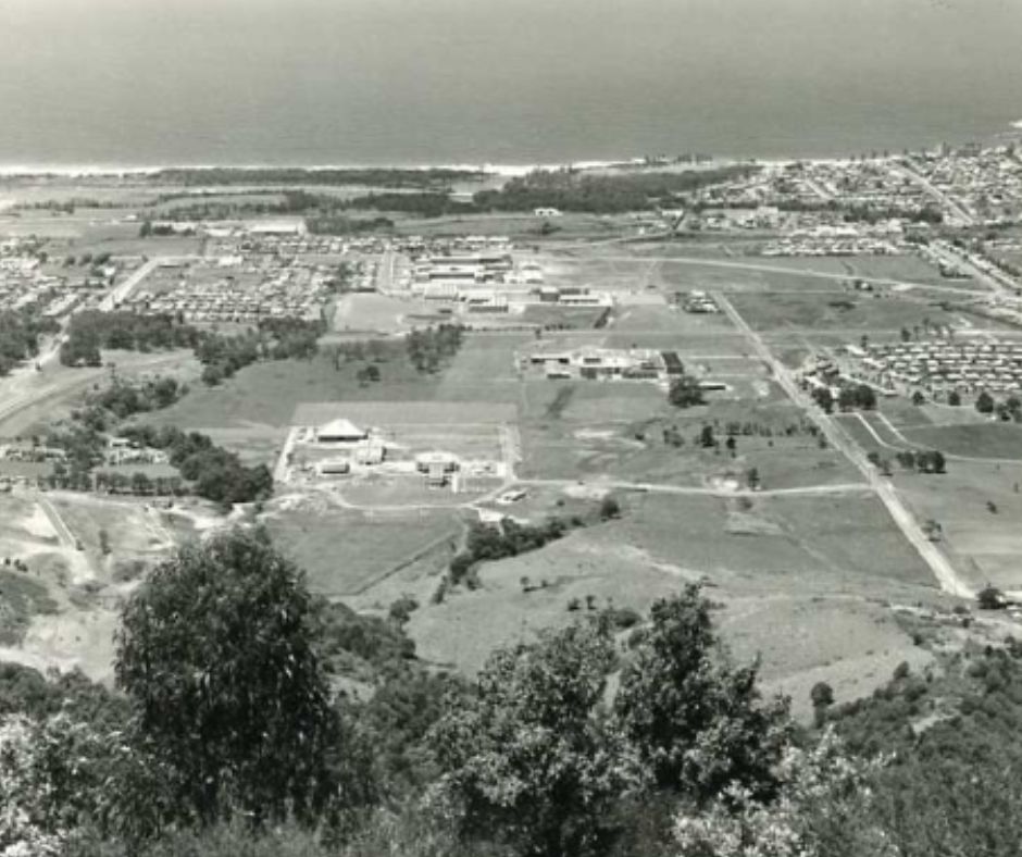
Top image: Keiraville, 1961. See image details on our catalogue