Parish: Kembla
County: Camden
Mount Kembla is a small suburb on the Illawarra escarpment, west of central Wollongong.
It is also the name of the iconic 'hat-shaped' mountain where the suburb is located.
Local communities of Aboriginal people were the original inhabitants and Traditional Custodians of Illawarra Land. Their dialect is a variant of the Dharawal language.
Before European settlement, the Aboriginal people of the region lived in small family groups with complicated social structures and close associations with specific areas.
Suburb boundaries do not reflect the cultural boundaries of the local Aboriginal community.
Traditional Custodians today are descendants of the original inhabitants and have ongoing spiritual and cultural ties to the Land and waterways where their ancestors lived.
Kembla is an Aboriginal word meaning "wild game abundant" or "plenty of game". Local Aboriginal people called the area "jum-bullah" or "Djembla" which means a wallaby.
Mount Kembla has been described as a "sub-tropical belt of rainforest" which "housed a variety of game life which provided an abundant food supply".
The first record of the name Mount Kembla appeared on H.F. White's map of the Illawarra in 1834.
American Creek
In the late 1800s American Creek was the name more generally applied to the Mount Kembla area. American Creek is the name of the creek which flowed through the valley. It is believed that it was called American Creek because in the 1840s three Americans came to the Illawarra and, with American axes, cleared some land on the banks of a beautiful creek flowing through Avondale.
Violet Hill
Violet Hill was a name given to the area of Mount Kembla south of the main road and near the school. The Public School at Mount Kembla was known as Violet Hill from 1859 to 1883.
Land grants
The first grant in the Parish of Kembla was made to George Molle in 1817. It was for 300 acres. In 1818 W. F. Weston received a promise of 500 acres. Both these grants were on the northern side of Mullet Creek.
On 28 March 1843 four grants were obtained by Henry Gordon which had frontages to American Creek. Shortly afterwards, another grant of 24 acres, also on American Creek, was issued to Patrick Lehaey. A settlement developed in this locality and in March 1859 a National School was completed here.
Other early land grantees in the area as shown on Parish maps include: Amelia Cecilia Georgina Beatson, David James, Edward Jekyll, William Stafford, William Vincent and John Gerard, and Henry Gordon.
A large area in the parish was unoccupied for some time and was referred to as the 'Great Reserve'. Much of the land on the mountain slopes was disposed of in numerous small portions by auction between 1831 and 1851 (Stone, 2002 ; Lindsay, 1994).
William Stafford
William Stafford was born in England in 1811 to William Stafford (Sr) and Hannah (Jane) Cockayne. Stafford married Elizabeth Goodall in 1830, and they had six children born in India, one dying, before the family came to Australia. William arrived in Australia with his family as a free man in 1852. He had served with the British Army in the 50th Regiment in India and was the Governor of Calcutta Gaol.
From the 1850s to 1864 he lived at Mount Kembla, running a farm. After settling in the Mount Kembla area, William and Elizabeth had another two children. Nearly all the children lived and had their own families at Mount Kembla. Both William and his wife died and are buried in Mount Kembla. One of the grandsons, David Kembla Stafford, died in the Mount Kembla Mine disaster of 1902 (Illawarra Family History Group, 1988).
John Graham
In 1863, Mr John Graham had taken up a grant of 180 acres on the slopes of Mount Kembla, along the banks of American Creek. Mr Graham was also one of the owners of the Company 'Graham and Mulholland', Commercial Agents, Sydney, that owned land at American Creek.
John Graham was the son of John and Jane (formerly McFarland) Graham, originally of County Tyrone, Ireland, who farmed land at 'Avondale' in the Illawarra. After the discovery of oil-producing shale on his property, and the subsequent opening of the Kerosene Works, John Graham became its first manager, and continued in this role until 1874.
While living in Mount Kembla, Graham married Jane Armstrong and raised a family. In 1874, Graham sold his share in the company and moved to Sydney. The discovery of the oil-producing shale, its subsequent mining, and the resultant mining of coal, ensured the development of the area (Ali, 1980 ; Stone, 2002; Illawarra Family History Group, 1988; Illawarra Mercury).
Robert James
James was born on the Berkeley Estate in 1834, and moved to the Mount Kembla area at the age of nine. He lived there for the next 80 years. His parents were William James and Isabella Munro. Mr James has many early memories of the area, which he shared with others. He is reputed to have been the first man to work the shale at Mount Kembla, and referred to it as the 'mother' of coal, not knowing what it was called.
Many of the fig trees in the surrounding area are said to have been sold by Robert James to local business men, including the fig tree at Mt. Keira hotel, and one still standing at Beaton Park. Mr James remembers driving cattle through the Bong Bong Pass, and bullocks to Wollongong with loads of potatoes and pumpkins, to be loaded onto boats over a temporary jetty made of planks of wood. The James family bull was harnessed with a horse's collar turned upside down, which were then put in the shafts of a dray. The bull pulled a load of over two tons along very rough unpaved mountain roads. Later, James' bull and dray was replaced by a mountain pony and sulky, to transport produce from the farm to Wollongong (Young, 1988).
Benjamin Rixon
Ben Rixon was a well known tracker and bushman who lived at Mount Kembla. He had the reputation of being the best non-Aboriginal tracker in Australia. In the days before much land clearing and built roads, many men got lost in the thick and inhospitable bushland. Rixon was so good at tracking and finding lost men and cattle that his services were in constant demand. His most famous rescue was of Charles Quin, whom he tracked for over a week before finding him, by then near death.
On 31 August 1857, Mr Rixon was presented with 100 Sovereigns at a public meeting held in Wollongong. Part of the presentation included a Certificate which stated "…he is universally held by the inhabitants of the Illawarra and neighbouring districts… for saving Charles Quin .. after a protracted period of nine days in the wilds of the Illawarra Mountain Ranges." (Illawarra Historical Society Bulletin, October, 1982; Old Pioneers Reminiscences, 1988).
The Pioneer Kerosene Mine
As early as 1849, oil-bearing shale from the slopes of Mount Kembla was tested by the Reverend W.B. Clarke. "Under the escarpment at the head of the Cordeaux River, and a little to the west of it and below Mount Kembla in the beds intersected by America Creek, a series of Shales exist with coal, a portion of which are found to produce oil."
Subsequently, the first kerosene mine in Australia was sited on a small plateau beside the American Creek. This is the present day site of the Nebo Colliery, but at the time the land was owned by Mr John Graham.
In 1865, R.J. Wants and Saul Samuel had taken a sample and showed a small vial of oil to Mr Graham. Mr Graham had the oil tested by a government analyst and this showed that every 1 ton of shale would yield 50 gallons of mercantile kerosene. When shale was found outcropping at several sites along the creek, men were employed to open up the deposit. An oil refining plant was constructed at a cost of 4,000 pounds, and the first load of mercantile oil was carted to Wollongong in December of that year.
W.J. Hammill, an American Oil Refiner, was engaged to supply plans and estimates for a retorting plant, later constructed by Longmore Co. in 1865, costing 4,000 pounds. The foundry works were supplied by P.N. Russel and Co. and Mr Hammill was in charge of the retorting operations. In July, 1865 the first buildings needed for production were built.
The first load of marketable oil was transported to Wollongong and sold by a Mr Herd, a local businessman. The kerosene produced won prizes at the Melbourne Inter-Colonial Exhibition in 1866-1867 and the International Exhibition in Paris, in 1868. By 1870, there were 23 retorts and 30 men employed and the proprietors were John, Edward and Neville Graham. This company was known as "Graham's Pioneer Kerosene Oil Works'. By 1870, private houses, business premises and public building were using the local oil.
The Graham family sold the business to the Mount Kembla Coal and Kerosene Co. in 1874, for $20,000, and the new company spent a large amount of money altering and modernising the plant. J.M. Fell became the new manager early in 1877. By 1876, the mine was idle and worked only intermittently after that, finally closing down in 1880 (Clarke, 1866; Stone, 2002 ; Illustrated Sydney News, Jan 18, 1873; Jervis, 1942; Fleming, 1967).
Coal Mining
Coal was first mined at Mount Kembla in 1865 to fire the retorts for the Pioneer Kerosene Works.
After John Graham sold his share of the Kerosene Works in 1874, the Mount Kembla Coal and Kerosene Company was formed and continued to operate until 1880, when the Mount Kembla Coal and Oil Co. commenced operations. The new company had formed as a result of the kerosene becoming uneconomical to produce, but the coal mined to operate the Works had proven to be extremely lucrative.
In March 1882 work began opening up an eight foot seam to the north of the kerosene mine. 60 men were engaged to work the seam, with William Green being the first mine manager.
The mining estate comprised 600 acres with approximately 200 more acres purchased and 500 acres leased for 99 years. In 1882, the mining company built the railway to Port Kembla, and the first coal shipped from Port Kembla was mined at Mount Kembla.
In 1887 a second mine was opened beneath the summit of Mount Kembla, but this proved to be costly and uneconomic, and was closed in 1890.
In 1888 it was proposed to mine coal north of the Mount Kembla pit with access along a rail which would follow the course of Brandy and Water Creek. Nothing happened here until 1954 when a tunnel and rail access was opened along this route as an outlet for coal from Kemira Colliery at Mount Kembla. These same tunnels provide access from Corrimal Colliery.
In 1970, the mine finally closed, having produced 14 million tons in just under 90 years.
In 1946 Nebo Colliery, a highly mechanised mine owned by Australian Iron & Steel, had been opened at the site of the old Kerosene Works. This colliery continues to be worked today. (Stone, 2002; Fleming, 1967).
In 2002, a new mine, Dendrobium, was established following much community consultation between BHP Billiton and local residents. Named after a local orchid, Dendrobium is said to be "a benchmark leader in the mining industry - a true 21st century coal mine" (The Advertiser, May 14, 2003).
The Dendrobium Mine is the first new mine in NSW in nearly 20 years, and produces premium quality coking coal for BHP Steel, Port Kembla. It was to commence production in 2004-2005, to coincide with the closure of Elouera Colliery, but the first coal was transported from the mine in June, 2003, ahead of schedule. In 2003 it was reported that the mine would employ 150 personnel and generate 800 direct and indirect jobs, with the potential to inject more that A$400 million in the local area (The Advertiser, May 14, 2003).
Railways
In 1878 the Mount Kembla Coal and Oil Co applied to the NSW government to construct a railway from Mount Kembla on American Creek to the Red Point, Five Islands, and also to Wollongong Harbour. In 1882 a railway was constructed by the Mount Kembla Coal and Oil Co. from Mount Kembla colliery to Port Kembla's first jetty (7.5 miles), at a cost of 3,000 - 4,000 Pounds. In the same year a rail incline was built from pit tunnel to the valley below (Stone, 2002; Singleton, 1984).
In 1887 the Mount Kembla signal box was built at Unanderra on the main southern Illawarra line, where the Colliery line crossed it. In 1889, a second crossing was opened by the Southern Coal Co., between its mine on the eastern Mount Kembla spur, and its separate jetty at Port Kembla. The Australian Coke Co. established its ovens next to this second crossing. They were served by a siding built in October 1889. In 1912 these works were closed. The Southern Coal Company's old crossing lay abandoned for many years, and its siding near the site of the coke works were closed in June 1917.
The crossing and signal box closed in 1949 when the overhead rail bridge was built (Stone, 2002; Singleton, 1984).
Roads
In 1821 O'Brien's Road was built by Cornelius O'Brien. It ran between Mount Keira and Mount Kembla, descending over the range to the 'Fig Tree'. O'Brien had been looking for an easier way into the Illawarra district than Throsby Track at Bulli, which was extremely steep (Shaw, 1970).
About 1865-1866 John Graham had completed a road "12 chains long and 20 feet wide from the mountain to the creek, across which a substantial bridge 60 feet long, 20 feet wide had been built. This is at the Kerosene Works" (Arthur Cousins, Garden of New South Wales: a history of the Illawarra and Shoalhaven districts 1770-1990, 1948). The road was significant because it was close to the Cordeaux and Mount Kembla areas, and gave settlers a way to travel into the area. By the 1840s Cordeaux Road was in use. It began where O'Brien's' Road intersected American Creek and the Southern Road, and became the chief way of getting into the area, which it remains to this day (Stone, 1974).
In 1858, the tender for the 'Cordeaux River Road' was accepted. It was, at the time, little more than a track. Cordeaux Road remained a tortuous and unsealed route from Figtree until the 1960s and 1970s, when the road was widened at the Waterfall and Henderson's Corner. In March 2003 the bridge deck of the Cordeaux Road Rail Bridge was upgraded, with a five week closure. The upgrade resulted from consultations between the local community and BHP Billiton during the Dendrobium Commission of Inquiry, and has been funded 50% by BHP Billiton and 50% by Wollongong City Council. The bridge deck has been replaced and the width of the bridge increased from 5 metres to 7.2 metres plus a 2.2 metre wide pedestrian footpath (Cousins, 1948: The Advertiser, May 14, 2003).
Head Master's Residence - Mount Kembla School
This residence is on Cordeaux Road, at the rear of Mount Kembla School, overlooking the village and looking toward the ocean. Designed by Government Architect, William Edmund Kemp, the residence was built in 1895-1896 in the typical "Cottage Classic" style. The home was constructed of brick, rendered, stood on freestone foundations and had a cedar interior. It replaced the original weatherboard residence. The first resident was Mr. A. Hamilton (Ali, 1981).
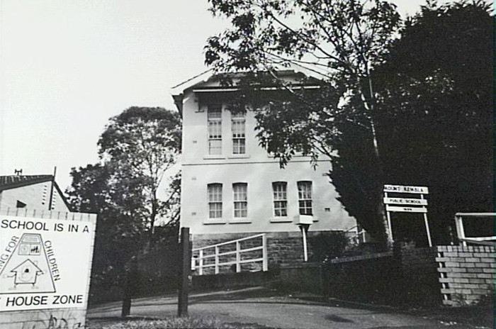
Image: Head Master's Residence, 1994, image number P11783.
Mount Kembla Hotel
This two storey building was built in 1887. It is constructed of weatherboard with a corrugated iron roof, and a timber front upstairs verandah. It was a meeting place for the miners of Mount Kembla for many years. In 1924 the Tooth's company purchased the hotel from its original owner, Mr O'Halloran, the village's first publican. Over recent years the interior has been extensively refurbished (Ali, 1981).
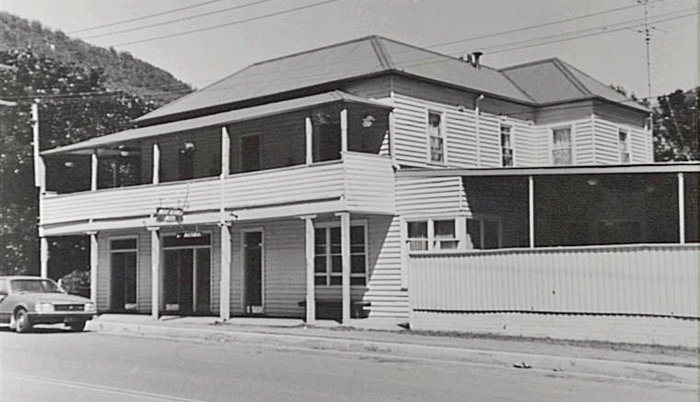
Image: Mount Kembla Hotel, 1982, image number P08192.
Miners' Cottages and Club Room
These single storey cottages were constructed in 1896 and are in Soldiers Road, Windy Gully (Kembla Heights). They were constructed with corrugated steel hip roofs, painted weatherboard wall and verandahs to street frontage. The row of miners' cottages and the Miners' Club Room is a unique group of buildings, representing a period of time and settlement of miners moving up the hill to Kembla Heights. Past owners include the Stacy, McNamara, Reece, Moran and Gallagher families (Ali, 1981).
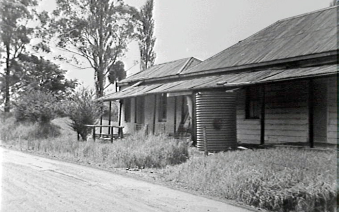
Images: Miners' Cottages, image number P03159.
Mount Kembla Post Office and Store
Located on Cordeaux Road, the post office / store was built in 1883 and is described as "a simple vernacular construction, built of weatherboards. A quiet reminder of the early days in the village." The first resident and Post Master for Mount Kembla was Mr John Graham (Ali, 1981).
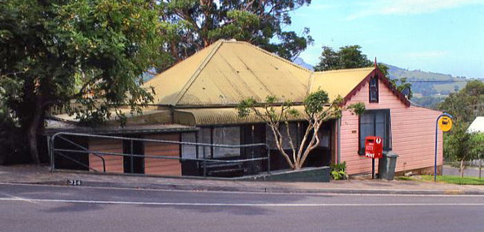
Image: Mount Kembla Post Office and Store, 2011, image number P20292.
Kembla Heights Village Conservation Area
These buildings were constructed around 1896. They were built for the miners in the area by the local mine company. The 1991 City of Wollongong Heritage Study describes the area as a "Mining village comprising of dispersed layout of similar weatherboard buildings with corrugated steel roofs" and "A rare and intact example of an early mining village in the Illawarra Region. Buildings are excellent examples of vernacular architecture from the Federation period. Dispersed pattern of dwellings with generous unfenced yards is a significant feature of the relationship to the landscape."
Although most of the buildings are owned privately, they are largely in fair condition and intact. The conservation area includes the visual catchment between the State Recreation Area ridge track at the top of the escarpment down to the creek line below the Nebo Colliery (City of Wollongong Heritage Study. Provisional Inventory. Volume 4. 1991).
"Mount Kembla is isolated and confined by steep topography, and consequently a unique character and identity has developed." (Register of the National Estate Database, 1998).
The western aspect of Mount Kembla is almost completely bounded by the Illawarra Escarpment State Recreation Area, while Charcoal Creek forms on the eastern face of Mount Kembla. Mullet Creek lies to the south and Goondarrin Creek in the north. American, Myrtle, Brandy and Waters Creeks all flow through this beautiful area. The recreation area and abundant bushland, along with only one major road bisecting the township, ensures the village's isolation and creates a unique timeless feel.
Warm temperate and sub-tropical rainforest once grew along the banks of American Creek. The rainforest merged into tall eucalypt open forest along the ridges. Today there are few remnants left of this belt which housed a variety of game life. However, over 120 endemic species still survive in the valley.
The southern sheltered slopes of Mount Kembla are covered with extensive palm forests and rich rainforest. The eastern and northern slopes are more exposed and obtain more sunlight.
Native animals in the area include the swamp wallaby, wombats and possums, the giant burrowing frog, red crowned toadlet and the broadheaded snake.
In 1804 the Logrunner bird was collected at Mount Kembla. This was the first of that specimen to be scientifically described. Other native birds include the spotted turtle dove, kookaburra, bower bird, superb blue wren, Australian magpie, pied currawong, Australian raven, common munah, honeyeater, welcome swallow.
Native trees include the Blackwood (Acacia melanoxylon); Native Peach (Trema aspera); Bastard Rosewood (Synoum glandulosum); Native cucumber (Sicyos australis); Hibiscus (Hibiscus heteroplyllus) (Environment Illawarra: Initiatives. 1995; Stone, 1984 & 2002; Fairley, 1999; Dendrobium Project, 2001; Farmborough Heights to Mount Kembla Strategic Planning Study, 1996).
| Date | Event |
|---|---|
| 1770 | Captain James Cook sights Mount Kembla and describes it as "a round hill the top of which looked like the crown of a hat" |
| 1796 | Matthew Flinders records Mount Kembla as Hat Hill |
| 1810 | Cedar getters commence felling cedar trees in the area |
| 1817 | First grant of land in the Parish of Kembla was made to George Molle |
| 1821 | Construction of O'Briens Road, passing between Mount Keira and Mount Kembla |
| 1834 | First record of the name 'Mount Kembla' on H. F. White's map of the Illawarra |
| 1843 | Land grants, with frontages to American Creek, made to Henry Gordon and Patrick Leahy |
| 1849 | Oil bearing shale from Mount Kembla tested by Rev. W. B. Clarke |
| 1852 | William Stafford granted property lots 74, 135 and 153 at American Creek |
| 1858 | Service in the first church at Mt Kembla (Church of England) |
| 1859 | First school at Mount Kembla established, originally known as Violet Hill |
| 1864 | Primitive Methodist Church established at Kembla Heights |
| 1865 | Pioneer Kerosene Works opened at Mount Kembla |
| 1878 | Mount Kembla Coal and Oil Co. established to work coal seams; E. Vickery principal shareholder |
| 1882 | Railway constructed by the Mount Kembla Coal & Oil Co from Mount Kembla Colliery to the Port Kembla jetty |
| 1883 | Post Office established at Mount Kembla on 1 October |
| 1883 | Mount Kembla Colliery opened |
| 1884 | Name of school changed from Violet Hill to Mount Kembla |
| 1887 | A second coal mine was opened directly below the summit of Mount Kembla |
| 1887 | Mount Kembla signal box was built at Unanderra on the main southern line |
| 1889 | Mount Kembla Gun Club established |
| 1894 | First Roman Catholic Church at Mt Kembla opened by Dr Higgins, Auxiliary Bishop of Sydney |
| 1896 | Workmen's Club formed at Windy Gully |
| 1896 | New two storey school building and teachers' residence opened on 18 April |
| 1898 | Mount Kembla Hotel receives confirmation of its licence |
| 1899 | Mt. Lyell Co. establishes coke ovens alongside Mount Kembla Colliery jetty - operated until 1925 |
| 1901 | 336 men employed at the Mount Kembla mine |
| 1902 | Mount Kembla Colliery disaster 31 July; 96 men and boys die |
| 1902 | Royal Commission Inquiry into the Mount Kembla Colliery disaster begins |
| 1905 | Memorial to the victims of the Mount Kembla Colliery disaster unveiled on 12 August |
| 1910 | Cordeaux Dam under construction |
| 1946 | Nebo Colliery opened on the site of the old Kerosene Works |
| 1950 | Mount Keira and Mount Kembla collieries joined by an underground tunnel to make Kemira Colliery |
| 1970 | Mount Kembla mine closes on 18 September |
| 1984 | Mount Kembla and Kembla Heights zoned as a village by Wollongong City Council |
| 2001 | BHP Billiton gives the go ahead to the $200 million Dendrobium mine at Mount Kembla. It is the first mine to be built on the southern coalfields in 20 years |
| 2004 | Nick Whitlam, the son of former Prime Minister Gough Whitlam, buys the historic Mount Kembla Hotel |
Ali, Anne C., Gazetteer of historic buildings, places and relics; Wollongong, Shellharbour, Kiama and Shoalhaven, [Wollongong, NSW]: A.C. Ali, 1980.
Ali, Anne C., Illawarra Region: Historic Buildings and Sites,Vol. II, Part 1, [Wollongong, NSW]: A.C. Ali, c1981.
Wollongong City Council and McDonald McPhee Pty. Ltd., City of Wollongong Heritage Study, [Wollongong, NSW: Wollongong City Council], 1991.
Clarke, W.B. (Rev). Quarterly Journal of the Geological Society 1866, Volume XXII.
Cole, Edward Sydney, Early history of 'Farmborough Farm' Mount Kembla N.S.W and of its founder & first owner Captain Robert Martin Cole R.N., Neutral Bay, NSW: The Author, 1979.
Cousins, Arthur, The Garden of New South Wales : a history of the Illawarra & Shoalhaven Districts 1770-1900, [New ed.], Wollongong, NSW: Illawarra Historical Society, 1994.
Dendrobium Project: Commission of Inquiry, [Wollongong]: BHP Illawarra Coal, 2001.
Fairley, Alan, Discovering Illawarra's bushland on foot, Sydney: Envirobook, 1999.
Forbes Rigby Pty.Ltd., Farmborough Heights to Mount Kembla strategic planning study, Wollongong, NSW: Forbes Rigby], 1996.
Fleming, A.P., The 'Pioneer' kerosene works at American Creek (Mount Kembla) NSW, 1865-1878, [Wollongong: Illawarra Historical Society], 1967.
Herben, Carol, Mount Kembla 1902 mine disaster commemoration cemetery walks, Balgownie, NSW: Mount Kembla Mine Disaster Centenary Commemoration Committee, 2002.
Illawarra Historical Society Bulletin, Wollongong, NSW: Illawarra Historical Society, 1945-
Illawarra Family History Group, Illawarra Pioneers Pre 1900, Wollongong, NSW: Illawarra Family History Group,1988.
Illawarra Mercury, Wollongong, NSW: Illawarra Newspapers Holdings, 1856-
Jervis, James. Illawarra: A century of history 1788-1888, Sydney: Royal Australian Historical Society, 1942.
Lindsay, Benjamin, Organ, Michael & Doyle, Peter, Early Land Settlement in Illawarra: 1804 - 1861, Woonona, NSW: Illawarra Historical Publications, 1994.
McCaffrey, Frank, The history of Illawarra and its pioneers, Haberfield, NSW: The author, 1922.
McDonald, William Graham (ed.), Earliest Illawarra / by its explorers and pioneers, Wollongong, NSW: Illawarra Historical Society, 1966.
McNamara, John Leo, Memories of Cordeaux, 2nd ed., [s.l.: s.n.], 1997.
Marshall, K. & Marshall, M, The ups and downs of the early roads to Wollongong. 1815 – 1888, Wollongong, NSW: Illawarra Historical Society, 1963.
Shaw, Hilde J, 200 facts about historic Illawarra, Wollongong, NSW: Illawarra Historical Society, 1970.
Singleton, Cyril Corbet, Railway History in Illawarra New South Wales, 4th ed., Wollongong, NSW: Illawarra Historical Society, 1984.
Stone, Kevin C., A profile history of Mount Kembla, 3rd rev. ed. Tamworth, NSW: Mt Kembla Mine Disaster centenary, 2002.
Warilla High School, Walks in the Southern Illawarra, Warilla, NSW: Warilla High Press, 1990.
Wollongong City Council, Wollongong City Council: proposed suburbs, Wollongong, NSW: Wollongong City Council, 2001.
Young, Frank et. al., Old Pioneer's Reminiscences of Illawarra: (1830's-1920's), Wollongong, NSW: Illawarra Historical Publications, 1989.
Top image: Mount Kemba, ca1938. See image details on our catalogue