Parish: Woonona
County: Camden
Mount Pleasant is a residential suburb on the Illawarra escarpment, a short distance from the centre of Wollongong.
Local communities of Aboriginal people were the original inhabitants and Traditional Custodians of Illawarra Land. Their dialect is a variant of the Dharawal language.
Before European settlement, the Aboriginal people of the region lived in small family groups with complicated social structures and close associations with specific areas.
Suburb boundaries do not reflect the cultural boundaries of the local Aboriginal community.
Traditional Custodians today are descendants of the original inhabitants and have ongoing spiritual and cultural ties to the Land and waterways where their ancestors lived.
Mount Pleasant
An early resident, John Dingwall, owned land in the Mount Pleasant area, having purchased it from John Buckland’s large estate, 'Balgownie' (see the Balgownie page for more details) and he named it 'Mount Pleasant'. The village of Mount Pleasant, located on the mountainside, developed as a mining town after the opening of the Mount Pleasant Colliery (or Mount Pleasant Mine) in 1861. While there were a few large residences, most houses were quite small, two rooms and a kitchen, and were built to house the miners and their families.
Babytown / Baby Town
Babytown was a nickname for the town of Mount Pleasant, given because of the number of large families that lived in the area.
Cramsville
Part of the area was known as Cramsville from the early 1860s until Balgownie School opened in 1889. The name came from Mr James Cram, who owned and subdivided land, and rented several small cottages to local miners. See the next section of this page for more information about James Cram.
John Dingwall
Born in 1801 in Cargill, Scotland, John Dingwall was a stone mason who immigrated to Australia in June 1838 with his son, John, his daughter Mary, and second wife Isabella. It’s interesting to note that there seems to be no information regarding his first wife, Mary Dinwiddie, to whom he was married in 1826 and who bore him his two children.
Wasting no time in acquiring land in this new country, in November 1838 Dingwall purchased a portion of land that had been auctioned off from the large Balgownie Estate. It wasn’t until 1840 that the land was transferred to Dingwall, for the sum of 135 pounds, six shillings, paid in full.
John Dingwall was the contractor for the first St Michael’s Anglican Church in Corrimal Street in Wollongong, which was opened in 1847. This structure was later demolished in 1859 after the Cathedral was built at its current location.
James Cram
Mr James Cram, an English immigrant, purchased 60 acres from the 'Balgownie' estate in approximately 1839. He was one of the first miners at the Mount Keira Mine when it opened for business in 1857. When the Mount Pleasant Colliery opened in 1861, the need for housing escalated, and Mr Cram set about subdividing his land into building lots and building several small cottages nearby for rental. He named this area Cramsville, and the name remained until 1889 with the opening of the Balgownie School.
For more information on early residents and land grants in this area, see the Balgownie page.
Mount Pleasant Colliery
Opened in June 1861 by Patrick Lahiff and his partner, Benjamin Fawcett, the Mount Pleasant Colliery was a boon for the area. Located on John Herbert Plunkett’s property, named 'Keelogues', the first load of coal was delivered on 13 July to Wollongong. The mine created the need for housing, which drove the subdivision of the larger properties and the construction of buildings for rental. The town sprung up around the mine.
In 1886 a second Mount Pleasant Mine was opened approximately 2.5 kilometres to the north of the first mine.
Rail
In 1862 a tramroad from the Mount Pleasant Colliery to the harbour was constructed in order to ensure the success of the company. Coal was initially transported down the mountain’s steep slopes by teams of oxen pulling sleds. When they reached the flat, they would then transfer this precious cargo onto carts and deliver to customers, local and further afield.
As the proposed tramway would cut through private land there was a strong protest. The Illawarra Coal Company, under the driving force of Mr Patrick Lahiff, lodged a bill in parliament known as the 'Mount Pleasant Tramroad Act', which, when it was accepted, gave them permission to proceed. It ran from the steep Mount Keira slopes and down across the flat farm lands between Fairy Creek and the foothills, then turned onto a reserve below what is now called Cliff Road, before finally joining the tram-road from the Mount Keira Colliery (Gilford, 1968).
Roads
The roads leading to Mount Pleasant and the surrounding areas were fraught with danger. They were notoriously steep and often in disrepair, churned up by the horse and carts that were the transport of the day. Mount Pleasant was accessed by what is now known as Mount Keira Road, described in the Evening News in 1870 as “a winding path of no great length round the sea-face of the mount”. This was first constructed in 1835-1836, making use of convict labour. Before this only bush tracks existed in the area, which were impassable in rough weather (O.H.M Consultants, 2006, p. 20).
Residence - Dobinson Street, Mount Pleasant
This house at 13 Dobinson Street was originally built by R J Thorne in 1888 (IM11.9.1888), the haulage contractor at Mount Pleasant colliery. The house was built of stone quarried behind Mount Pleasant Mine. The house was later remodelled. The original house can be seen behind the ironwork on the lower level.
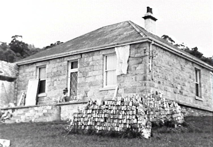
Image: 13 Dobinson Street, 1981, image number P02281.
See the Balgownie page for details of other historic buildings in this area.
Location
Located on the eastern slopes below Mount Keira, the natural environment of Mount Pleasant consists of tall, open forests of eucalypts interspersed with irregular patches of rainforest in small, sheltered locations. The coal mining activities which began in 1860 made a significant impact on the natural environment, described as “every mine on the escarpment meant a hole punched in the forest” (Fuller, 1982, p. 11).
Threats
The current environmental threats are common to all suburbs along the escarpment. The widespread infestation of feral animal species impacts heavily. The large number of deer pose a risk to motorists, destroy the fragile environment, cause erosion, and damage the delicate ecosystem in which there are several vulnerable and endangered flora and fauna species. Foxes and feral cats are also marked as threat species by the National Parks and Wildlife Service (2003).
There is also the introduced flora threats of lantana and other major weeds such as pampas grass, cassia, privet, and crofton weed (National Parks and Wildlife Service, 2003), which damage biodiversity by rapidly reproducing and outcompeting native vegetation. Weed management is undertaken regularly by the NPWS and Wollongong City Council.
| Date | Event |
|---|---|
| 1829 | John Buckland is promised a land grant of 1920 acres, names it 'Balgownie' |
| 1838 | John Dingwall purchases a portion of land from an auction, names it 'Mount Pleasant' |
| 1861 | Mount Pleasant Colliery opened by Mr P. Lahiff on Plunkett’s property |
| 1862 | The tramway from Mount Pleasant Colliery to Wollongong Harbour constructed after being rushed through parliament |
| 1868 | Second Mount Pleasant Colliery opened 2.5 km north of the original |
| 1889 | Balgownie Public School opened |
| 1889 | Mount Pleasant Coke Works built near the railway bridge in North Wollongong |
| 1933 | Mount Pleasant Colliery ceases production |
| 1934 | Mount Pleasant Colliery goes into liquidation |
| 1937 | BHP takes over the colliery (now named Keira Pleasant Tunnels) |
| 1939 | Mount Ousley Road begins construction (Main Rd 513 and Trunk Rd 95) |
| 1941 | Mount Ousley Road completed and opened |
| 1955 | Colliery closed and sealed |
| 1957 | Mount Pleasant Sports and Social Club opens |
| 1969 | Rhododendron Park established by members of the Illawarra branch of the Australian Rhododendron Society |
| 1969 | Pleasant Heights Public School established |
| 1978 | Mount Pleasant Sports and Social Club closes |
| 1978 | Mount Pleasant Coke Works (at North Wollongong) ceases operation |
Devereaux-Dingwall, Mavis & Dingwall, Glenda & Pope, Sharelle, The Dingwall pride. Kings Langley, NSW: M Devereaux-Dingwall, 2007.
Francis, L. M. Balgownie: 1889 and all that. Keiraville, NSW: Wollongong Institution of Education, 2008.
Fuller, Leon & Badans, Russell, Wollongong's native trees (2nd ed). [Thirroul, NSW]: L. Fuller, 1982.
Eardley, Gifford H. (Gifford Henry) Transporting the black diamond. Book 1., Colliery railways of the Illawarra district, NSW (Central Section). Canberra: Traction Publications, 1968.
National Parks and Wildlife Service, Illawarra Escarpment State Conservation Area Issues Paper: in preparation for a Draft Plan of Management, http://www.environment.nsw.gov.au/resources/parks/pomIssuespaperIllawarraescarpment.pdf [website] accessed May 2003.
O.H.M Consultants, Strategic Management Plan for Historic Coal Mining Sites of the Illawarra. Wollongong City Council & New South Wales Dept. of Primary Industries, Mineral Resources Division, 2006.
Wollongong Coal Mines - Mount Pleasant (1870, November 4, 1970, p.4.) Evening News, Sydney, NSW.
Top image: Mount Pleasant Colliery engine sheds, 1907. See image details on our catalogue