Parish: Woonona
County: Camden
Russell Vale is north of the centre of Wollongong, between Corrimal and Woonona.
Local communities of Aboriginal people were the original inhabitants and Traditional Custodians of Illawarra Land. Their dialect is a variant of the Dharawal language.
Before European settlement, the Aboriginal people of the region lived in small family groups with complicated social structures and close associations with specific areas.
Suburb boundaries do not reflect the cultural boundaries of the local Aboriginal community.
Traditional Custodians today are descendants of the original inhabitants and have ongoing spiritual and cultural ties to the Land and waterways where their ancestors lived.
Russell Vale was the estate of F. P. MacCabe who took up land there in about 1850. His son, who died from an accident, was called Russell and this was one suggestion of where the name Russell Vale came from.
The other possibility, which is more likely as the house was built before Francis had any children, is that Francis' mother's maiden name was Russell and he named the property after her family (McDonald, 1988).
Harriet Spearing (nee Overington)
The suburb of Russell Vale was part of a large land grant which was promised to Miss Harriett Overington on 3 March 1827 by Governor Darling. The grant consisted of 1,920 acres north of the Buckland grant. This passed to James Spearing when he married Harriett, and became part of his estate. In the 1830s the Spearings decided to leave the Illawarra. This resulted in Robert and Charles Campbell being issued the deeds by Governor Gipps on 30 April 1841.
Michael Cawley
In 1850 Cawley's Estate made up part of what is today Russell Vale. It was located on the eastern side of the Princes Highway.
Francis Peter MacCabe
Francis was born to Dr James and Margaret (nee Russell) MacCabe in Dublin in 1817. At age 16 Francis joined the Ordnance Survey of Ireland and trained as a surveyor. In 1841 he was granted an appointment with the Surveyors of England to go to New South Wales. Francis embarked on the ship 'Florentia' on 6 June 1841, arriving in Australia on 26 October 1841. He worked in a variety of locations in Australia before settling in the Illawarra.
In January 1853 Francis reported for duty in the Wollongong area. Soon after, he met Jane Osborne (born 30 January 1830). Jane was the eldest child of Henry and Sarah Osborne of Marshall Mount. Francis and Jane married in St Luke's church in Brownville on 28 November 1855.
During 1855 the couple built and moved into 'Russell Vale' house in what (at the time) was called Bulli. The MacCabe Estate was on the western side of the Princes Highway under the escarpment. Francis' mother's maiden name was Russell and it is possible that the name of the house and later the estate was named after her. Francis and Jane had 14 children during their marriage.
Francis left the employ of the Department of Surveyors in August 1856 and became the manager of the mine near 'Russell Vale' house. The mine had been bought by Osborne (Jane's father) and Wallsend. Francis remained manager of the mine until 1883 when his son Henry MacCabe took control.
Francis had political ambitions and stood for parliament in 1859. He was defeated at this time but this did not stop him. Francis was on the very first North Illawarra Council and then served as its Mayor in its second year. Francis, who was regarded as a just person by many, also served as a Justice of the Peace in Wollongong.
It was only due to ill health that the MacCabe family retired to their property at Bowral. Francis died there on 27 June 1897. An obelisk was erected at the Corrimal Catholic Cemetery by his wife. It was a polished red granite affair surmounted by a celtic cross. It was inscribed with the following:
F.P.MacCabe
Born 17th April 1817
Died 27th June 1897
6th son of the Late James MacCabe MD of Dublin
Erected by his wife
(Local Studies Cutting Files; Illawarra Mercury,16 March 2000; Illawarra Historical Society Bulletin, 1992).
Henry Osborne MacCabe
Henry was the eldest son of Francis and Jane MacCabe. He was born on 18 November 1856 at Marshall Mount, home of the Osborne family. Henry was a licensed surveyor like his father and qualified as a mining engineer. He served his apprenticeship in colliery engineering and management in England during the late 1870s. In 1883 he took over control of the Osborne and Wallsend mine from his father, where he stayed for 14 years.
Henry served his community in many things. He was an alderman and eventually the Mayor of the North Illawarra and Wollongong Councils. He was also the Chairman of the Harbour Trust for a time and a senior warden of the South Lodge of Freemasons. Henry also became the Commanding Officer with the rank of Major for the No. 6 Company of the NSW Artillery.
Henry married Marion, the daughter of R.T. "Dean" Ewing, and had one son and two daughters. Henry was known to be a 'manly man' who recognised God in all things. He was always punctual and his word was his bond.
Henry was best known in the community as the hero of the Bulli and Mount Kembla mine disasters. He was a leader of one of the rescue parties first into the mine during the Bulli mine disaster of 1887.
When an explosion occurred in the Mount Kembla Colliery in 1902, Henry was one of the first to volunteer his services in the rescue operation. There were 261 men trapped below and Henry did not hesitate to go in to rescue them. Henry was one of two rescuers that lost their life in the attempt to free the trapped men. All but 94 men were eventually rescued (Local Studies Cutting File).
Coal Mining
Gujurat NRE No. 1 Colliery, as it is currently known, played a large part in the beginnings of Russell Vale, and still does today. The original proposal was for a mine and a tramway to be worked by Taylor and Walker.
The mine opened in 1861 above the MacCabe house 'Russell Vale', at the foot of the mountain. Due to an economic depression the mine closed in 1864.
The Osborne family re-opened the mine in 1886-1887 as the South Bulli Colliery under the management of W. Wilson. In 1899 the mine was purchased by Ebenezar Vickery, then in 1900 Bellambi Coal Company bought the mine.
The Bellambi Coal Company owned the mine until fairly recently, and named it South Bulli Colliery. The mine had a considerable impact on the local population whose lives were largely entwined with the mine. One of the earliest power houses ever built in Australia was built by the South Bulli Colliery in 1902 (Bayley, 1989; Russell Vale Local History Group, 1994).
Brickworks and Clay Pits
In 1909 the Illawarra Fireclay and Brick Company opened their clay pits and brickworks in Russell Vale. The clay pits were situated on land which is now part of the Russell Vale Golf Course. The brickworks were located on the eastern side of the highway in York Road. In 1936 another brickworks was opened in Russell Vale (Russell Vale Local History Group, 1994).
Agriculture
Other parts of land in Russell Vale were opened up to small scale farming. There were a variety of crops cultivated including various fruits and vegetables. The land was opened up to grazing and the dairy cows supplied milk for butter and cream (Russell Vale Local History Group, 1994).
In the early years of Russell Vale the only way in and out of the suburb was by horse or on foot. The settlement of Russell Vale was mainly confined to the escarpment side of the modern highway, with Brokers Street and Moreton Streets the focus of the early settlement. The rest of Russell Vale remained bush land with some paddocks and a track to Bellambi running through it until the late 1920s.
During the late 1840s the settlers of Fairy Meadow, under the Parish Roads Act, elected several trustees to plan a road to the northern suburbs. The road was constructed of dirt from the water tables. Access to Russell Vale and the northern suburbs was made easier with the blasting of Black Cutting Hill around the 1870s.
There was a tramway from the South Bulli Colliery to the port at Bellambi to carry the coal from the mine to the port. This was constructed in the mid 1800s. At first they used horse and bullock for drawing the wagons but in 1867 these animals were replaced with six locomotives with hopper wagons (Russell Vale Local History Group, 1994).
Russell Vale Community Hall
Address: Keerong Avenue (corner of Channon Street)
The Russell Vale Community Hall was opened in 1954 by the Chairman of the Joint Coal Board, Mr F. S. Cochrane. This piece of land was acquired by the Russell Vale Progress Association in 1950. The first reference to the Community Hall was in 1948 when the local ratepayers levied themselves a penny in the pound to go towards building the hall.
The total cost of building the hall was £9000. The money was raised by the local community, local businesses, local industrialists and the Municipal Council. The Joint Coal Board contributed half of the cost from its Welfare Fund. Alderman Williams said that this was the "culmination of many years agitation and work towards the ideal of establishing a Community Hall." (Illawarra Mercury, 1954).
Eventually the building became derelict. The Russell Vale Public School Parents and Citizens Group decided to make it shine again. There is a close relationship between the Community Hall and the Russell Vale School. This is because when the school was started it was originally held in the Community Hall. For the 50th anniversary of the building they did major renovations. The flooring was removed and the wooden floor was polished, a new coat of paint was applied and a gazebo was erected nearby. The Community Hall is now used for a variety of purposes. Playgroup is held there as well as ballet classes, and occasionally the hall is rented out for events such as 21st birthday and engagement parties (Advertiser, 14 April 2004; Illawarra Mercury, 1954; Russell Vale Local History Group,1994).
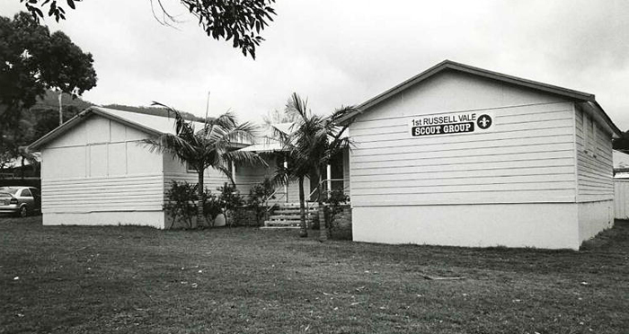
Image: Russell Vale Community Hall, 2007, image number P18172.
Visit Council's website for venue booking information.
South Bulli Colliery Signal Box
Location: corner of Bellambi Lane and Princes Highway
The South Bulli Colliery Signal Box was constructed to be used as a gate and semaphore box at the crossing to Bellambi Wharf. It was officially opened on 5 October 1910. The building is constructed of local brick and timber with a corrugated iron roof. The building is significant as a reminder of a time when coal was transported along the tramway to the now demolished wharf at Bellambi (Ali, c1981).
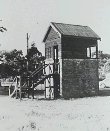
Image: South Bulli Colliery Signal Box, image number P09143.
Russell Vale is part of the Illawarra coastal plain and is surround by Corrimal, Bellambi and Woonona, with the Escarpment to the rear. The coastal plain is approximately three kilometres wide at Russell Vale.
There are three distinct areas in Russell Vale; the Escarpment, the mine site and low density residential housing.
Russell Vale is also part of the Bellambi Creek catchment area, as Rasts Gully Creek is a tributary leading to Bellambi Creek (Environmental Impact Statement Coal Washery Reject Emplacement in the Southern Gully, Russell Vale, NSW, Stage 3, August 1989).
The most dominant feature of Russell Vale is the Escarpment. At some points the Escarpment rises to a height of 500 metres. The Escarpment is mostly in its natural state with the slopes covered in dense tree coverage. Rainforest is found in scattered pockets along the Escarpment (Environmental Impact Statement Coal Washery Reject Emplacement in the Southern Gully, Russell Vale, NSW, Stage 3, August 1989).
The Gujurat NRE No. 1 Colliery takes up a large section of Russell Vale and has resulted in the clearance of native vegetation in this area. On the mine site lantana and blackberries are prevalent, as well as large areas of grasses. The land which the Russell Vale Golf Course is on has also been cleared. This land was previously used as a garbage dump and mine waste dump (Environmental Impact Statement Coal Washery Reject Emplacement in the Southern Gully, Russell Vale, NSW, May 1985).
Spread throughout Russell Vale amongst the houses are many varieties of trees including Blackbutt, Grey Ironbark, Forest Red Gum, Turpentine, Ironwood, Cabbage Palms, Red Cedar and Cheese Trees to name a few (Environmental Impact Statement Coal Washery Reject Emplacement in the Southern Gully, Russell Vale, NSW, May 1985).
The native fauna includes small mammals such as bandicoots, rats and echidnas. Wallabies and kangaroos can be found on the Escarpment as well. Bird life includes Kookaburras, pigeons, butcher birds, magpies and an abundance of Yellow Crested Cockatoos (Anthony, 1994).
| Date | Event |
|---|---|
| 1817 | Francis Peter MacCabe born in Dublin |
| 1841 | Miss Harriett Overington is promised a land grant of 1,920 acres by Governor Darling |
| 1841 | Robert and Charles Campbell issued deeds of grant formerly promised to Harriett Overington by Governor Gipps |
| 1846 | Fairy Meadow settlers elect trustees under the Parish Roads Act to organise a road north |
| 1855 | Francis MacCabe marries Jane Osborne |
| 1855 | 'Russell Vale' house completed |
| 1856 | Henry Osborne MacCabe born |
| 1858 | Mine above 'Russell Vale' house proposed with a tramway to Bellambi by Taylor and Walker |
| 1859 | Henry Osborne buys 50% of the mine |
| 1864 | Mine closed due to a depression |
| 1864 | Michael Cawley plants two fig trees to celebrate the birth of his daughter |
| 1867 | South Bulli Colliery replaces the bullocks and horses that draw the trams to Bellambi with six locomotives with hopper wagons |
| 1883 | Henry Osborne MacCabe takes over management of the mine |
| 1886 | The mine re-opens as the South Bulli Colliery by Osborne and Wallsend managed by W. Wilson |
| 1887 | Bulli mine disaster |
| 1890 | Mine sold to Ebenezar Vickey |
| 1897 | Francis MacCabe dies in Bowral |
| 1900 | Bellambi Coal Company bought South Bulli Colliery |
| 1902 | Mount Kembla Colliery mine disaster; Henry MacCabe dies as a hero of the disaster |
| 1902 | South Bulli Colliery builds one of the earilest power houses in Australia |
| 1902 | The MacCabe Russell Vale Estate first subdivision sold; 96 choice allotments |
| 1904 | The MacCabe Russell Vale Estate second subdivision sold; largest land sale in the district |
| 1909 | Illawarra Fireclay and Brick Company opens their clay pits and brickworks |
| 1914 | Mining stops until shortly after the war begins |
| 1919 | Mine re-opens |
| 1926 | The Southern Mines Rescue Station was completed |
| 1930s | The first shop in Russell Vale was opened by Matt Suddick |
| 1933 | Russell Vale Progress Association formed |
| 1936 | A second brickworks is opened in Russell Vale |
| 1939 | Brickmakers' Union formed on the South Coast |
| 1940 | Cawley Park opened on land donated by John Cawley |
| 1940s | Mrs Bishop opens the first Post Office in Russell Vale |
| 1940s | The building of the first housing commission houses begins in the lower part of the old Cawley Estate |
| 1944 | Russell Vale Progress Association institutes a local rate of levy to pay for the building of a community hall |
| 1949 | Strike over Kemira Tunnel for 16 weeks |
| 1954 | Russell Vale Community Hall built; opened by State member for Bulli, Lawrence Kelly |
| 1954 | Russell Vale School starts in the Community Hall |
| 1955 | Russell Vale School opens its own buildings |
| 1955 | First modern septic tank for the district is installed at the school |
| 1965 | First Principal of the Russell Vale School, Mr Tom Nairns, dies |
| 1966 | Russell Vale House demolished |
| 1978 | Wollongong City Council forms the Golf Course committee |
| 1981 | The construction of the golf course begins; it is to be 18 holes, par 3 |
| 1986 | Offical opening of Russell Vale Golf Course |
| 2004 | The mine is bought by an Indian company and renamed Gujarat NRE. No.1 Colliery |
Ali, Anne C., Illawarra Region: Historic Buildings and Sites, [Wollongong, NSW]: A.C. Ali, c1981
Anthony, Leanne, An Environmental Management Plan for Bellambi Creek Catchment, Wollongong, NSW: Wollongong City Council, 1994.
Bayley, William. Black Diamonds. 4th ed. Illawarra Historical Society, 1989.
Cousins, Arthur, The Garden of New South Wales: a history of the Illawarra & Shoalhaven Districts 1770-1900, [New ed.], Wollongong, NSW: Illawarra Historical Society, 1994.
Environmental Impact Statement for coal washery reject emplacement in the Southern Gully on part portion 151 Russell Vale, NSW for the Bellambi Coal Company Pty Limited, [Sydney?]: Longworth and McKenzie, c1985
Illawarra Historic Society Bulletin, The MacCabes of Russell Vale. Illawarra Historic Society, August 1992.
Johnstone Environmental Technology Pty. Limited & Bellambi Coal Company Pty. Limited, Environmental Impact Statement: Coal Washery Reject Emplacement in the Southern Gully, Russell Vale, NSW, Stage 3, [S.l.]: Johnstone Environmental Technology, 1989.
Lindsay, Benjamin, Organ, Michael & Doyle, Peter, Early Land Settlement in Illawarra: 1804 - 1861, Woonona, NSW: Illawarra Historical Publications, 1994.
Local Studies Cutting File.
McDonald, Lorna. Gladstone: city that waited. Boolarong for Gladstone City Council, 1988. pp.77-85. in MacCabe Family Papers [manuscript], MSS 323.
Nairns, Mollie G., A Synopsis of the History of Russell Vale Public School 1954-1965, Russell Vale, NSW: Russell Vale Public School, 1966.
Russell Vale Local History Group. As we Remember: a history of the Russell Vale Community from the early 1900s to the 1950s. Russell Vale Community Arts Association, 1994.
Top image: Keerong Street, Russell Vale. See image details on our catalogue