Parish: Wollongong
County: Camden
Warrawong is a large residential and commercial centre on the northern shores of Lake Illawarra.
Local communities of Aboriginal people were the original inhabitants and Traditional Custodians of Illawarra Land. Their dialect is a variant of the Dharawal language.
Before European settlement, the Aboriginal people of the region lived in small family groups with complicated social structures and close associations with specific areas.
Suburb boundaries do not reflect the cultural boundaries of the local Aboriginal community.
Traditional Custodians today are descendants of the original inhabitants and have ongoing spiritual and cultural ties to the Land and waterways where their ancestors lived.
Various meanings are given for the Aboriginal word Warrawong, including "a whiting", "side of a hill", "a windy place on a hill", and "wind-swept".
The Warrawong area has been known variously as Steeltown, Kembla Estate, New Kembla and, finally, Warrawong.
The use of the name Warrawong was first recorded in a South Coast Times article of 1936 (South Coast Times, 4 September 1936).
Land Grants
Surveyor General John Oxley marked out the first land grants in the region on 2 December 1816. He marked out large parcels of land surrounding Lake Illawarra which were named Illawarra Farm, Berkeley Estate and Macquarie Gift. Crops such as wheat, oats and potatoes were grown around the lake and dairying became the primary industry in the late 1880s.
In 1817, David Allan was granted 2,200 acres at Five Islands. His property fronted the ocean at Red Point and Port Kembla and was between Tom Thumb Lagoon and Lake Illawarra. The grant was called 'Illawarra Farm'.
Allan was Deputy Commissary-General of the colony from 1813 to 1819. He carried on his grazing interests on his 'Illawarra Farm' of which 600 acres were cleared. Produce from the farm was sold to the Government Stores. Allan left the colony in 1822 and he leased the farm "with good cottage and office" (Sydney Gazette, 22 June 1824).
In 1827 the property was sold to Richard Jones, who later sold it to William Charles Wentworth and it came to be known as 'The Five Islands Estate'. Wentworth died in 1876. leaving the property to his son D'Arcy Bland Wentworth.
In 1899, 500 acres of the land was resumed for the Port Kembla Harbour and a further 1470 acres was resumed in 1913 (Herben, 2000).
Wentworth Family
The Wentworth Family had a long association with the Warrawong / Port Kembla area. William Charles Wentworth I purchased Illawarra Farm, later known as Five Islands Estate, from Richard Jones. He died in 1876 and left the property to his son D'Arcy Bland Wentworth. D'Arcy Bland died without heirs and his nephew, William Charles Wentworth III, inherited the Five Islands Estate.
W C Wentworth III sold some of the land to Australian Iron and Steel to enable them to move from Lithgow to Port Kembla, and some to a group of Sydney businessmen called 'Heart of Kembla'. The Wall Street crash of 1929 and subsequent Depression meant that Heart of Kembla became bankrupt, and as the land had not been paid for it reverted to W C Wentworth III (Lawson, 1991).
In 1935, W C Wentworth IV began to develop parcels of land from his estate for sale. He granted four acres of land for a new school at Steeltown (Warrawong) and built a new Kembla Estate hall at Port Kembla (South Coast Times & Illawarra Mercury).
When the land at Warrawong was subdivided, the Wentworths would not allow inferior structures to be built in case they developed into slums. The subdivisions included unusual features for the time such as wide streets, kerbing and guttering, and underground drainage, as well as recreational areas and parklands (South Coast Times, 30 August 1935).
Although the Wentworth family owned the Kembla Estate for over 100 years, they did not live in the district for any length of time. The land was leased or managed through a family trust.
Dairying
David Allan, the first land grantee in the area, carried on grazing interests on his 'Illawarra Farm' of which 600 acres were cleared. Produce from the farm was sold to the Government Stores. Crops such as wheat, oats and potatoes were grown around the lake and dairying became the primary industry in the late 1880s.
Lake Illawarra
In the 1890s, attempts were made to make Lake Illawarra a deep sea port. A jetty was to be built on the western shore of the lake to allow the export of coal from the Ocean View colliery. As part of this scheme, a channel was to be dredged through the entrance of Lake Illawarra to allow ocean-going boats to reach the lake jetty. The channel was to be four and a half miles long and 430 feet wide between the breakwaters at the lake entrance. A railway line was built on Windang Island to carry rock cut from the southwestern side of the Island through to the mainland side of the Island. This rock was used to build the breakwaters, the remains of which can be seen today. The project was abandoned in 1902 because of the problem of drifting sand blocking the lake entrance channel (Lake Illawarra Authority).
Port Kembla District Hospital
Address: Cowper Street, Warrawong
W C Wentworth first offered land for a hospital in Keira Street, Port Kembla. In 1923, this land was found to be unsuitable as it was not large enough.
After many years, demand for a hospital south of Wollongong grew and land in Warrawong was found to be suitable. The hospital was designed by the Government Architect, E H Farmer, and opened in January 1965. It is on Cowper Street, Warrawong and has views of Lake Illawarra and the Pacific Ocean.
The hospital was built at a cost of almost £2 million. At the time it was the biggest hospital on the South Coast.
Design ideas were drawn from the Nuffield Report, a six-year study into the function and design of hospitals (University of Bristol; South Coast Times, 28 January, 1965).
The Illawarra Area Health Service now manages the hospital.
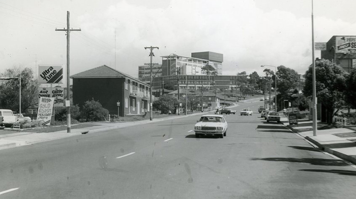
Image: Port Kembla District Hospital, 1983, image number P21011.
Open Hearth Hotel
Address: King Street, Warrawong
The Open Hearth Hotel was originally built as a boarding house by the Wentworth family in 1939 to provide accommodation for the engineers and their families who came from the United States to start up Commonwealth Rolling Mills. It was known as the Commonwealth Hostel.
It became a hotel in 1948 and in the 1960s sold more beer than any other country hotel in NSW (Illawarra Mercury, 13 March 1979). It still operates as a hotel.
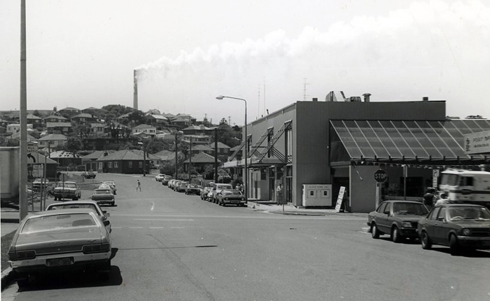
Image: Open Hearth Hotel, 1983, image number P21005.
Warrawong is located on the shore of Lake Illawarra, a valuable natural resource and habitat for local wildlife. See the Windang page for more information.
Lake Illawarra is a shallow coastal lagoon approximately 31 square kilometres in area. The lake has approximately 39 kilometres of shoreline, very little of it remaining natural. It is predominantly an urban lake with 68% of the shoreline covered in urban or industrial development. The wetland areas of the lake provide habitats that are used extensively by waterbirds.
The following species are found on the lake:
- Pelicans
- Cormorants
- Musk Ducks
- Hoary-headed Grebes
- Black Swans
- Black Ducks
- Grey Teal Ducks
- Herons
- Ibises
- Spoonbills.
| Date | Event |
|---|---|
| 1934 | First houses in the Warrawong area |
| 1935 | Steeltown Public School opened on Flagstaff Road |
| 1936 | First shop in shopping centre |
| 1936 | Commonwealth Hostel opened (later became Open Hearth Hotel) |
| 1936 | Post office opened |
| 1940 | St Andrews Anglican Church, Cowper Street, built on land given by W.C. Wentworth (demolished 1999) |
| 1946 | School renamed to Warrawong Public School and transferred to Cowper Street site |
| 1948 | Odeon Theatre opened |
| 1949 | Open Hearth Hotel opens (built 1936 as a boarding house for steelworkers) |
| 1960 | Warrawong Shopping Centre opens |
| 1960 | St Francis of Assisi School opens |
| 1972 | Warrawong High School opens |
| 1972 | Waghorn family opens the Gala Cinema, after converting part of the former Odeon Theatre which had closed in 1971 |
| 1988 | Westfield Shoppingtown opens, includes a Hoyts multi cinema complex |
| 1988 | New library opens in Westfield Shoppingtown (combining Warrawong, Berkeley and Port Kembla libraries) |
| 2006 | Stormwater quality improvement device installed at Kully Bay |
| 2006 | Warrawong Catholic Church celebrates 50 years (Illawarra Mercury 11/04/06) |
| 2006 | Launch of Laneway 127 art project (Illawarra Mercury 10/09/06) |
| 2010 | New Warrawong Library is opened on King Street (Illawarra Mercury 30/11/2010) |
Top image: Cowper Street, Warrawong. See image details on our catalogue