Parish: Kembla
County: Camden
Cleveland is a suburb in West Dapto, in the south west of Wollongong Local Government Area.
Local communities of Aboriginal people were the original inhabitants and Traditional Custodians of Illawarra Land. Their dialect is a variant of the Dharawal language.
Before European settlement, the Aboriginal people of the region lived in small family groups with complicated social structures and close associations with specific areas.
Suburb boundaries do not reflect the cultural boundaries of the local Aboriginal community.
Traditional Custodians today are descendants of the original inhabitants and have ongoing spiritual and cultural ties to the Land and waterways where their ancestors lived.
The boundaries of Cleveland were established as part of the planning process for the West Dapto area, first earmarked for urban development in the 1970s.
The name Cleveland was originally proposed in 1993, but was not officially gazetted until 5 August 2005. It derives from the name of the historic homestead located near the south-western corner of the area.
Cleveland is made up of parts of several early Illawarra land grants.
Colonel George Molle
Cleveland contains at least part of “300 acres … granted to Colonel George Molle on 11 September, 1817, by Governor Macquarie. This was a very modest allotment in comparison with the large areas granted by Macquarie to others in Illawarra. [Molle] was Lieutenant Governor of the Colony and Commandant of the Forces at that time, and Macquarie and he had been fellow campaigners in the Peninsular Wars” (Lindsay, 1934, p. 19).
This small allocation was possibly due to Molle’s “strained” relations with Macquarie as a result of the latter’s “humane and generous policy towards Emancipists” which brought Macquarie “into conflict with Army officers” with whom Molle “strongly sided” (Lindsay, 1934, p. 19). Molle reputedly secured significant allocations elsewhere, “1800 acres at Cook, 1550 acres at Minto” (Cousins, 1994, p. 41).
E.R. Stack, Fitzgerald family, James Blanch and George William Paul
Other early grants either partly or wholly contained within Cleveland are:
- E.R. Stack (300 acres, on 20 May 1837)
- Fitzgerald family (75½ acres, Court of Claims grant)
- James Blanch (200 acres, granted on 20 February, 1839)
- "An area of 600 acres .. granted to George W. [William] Paul on 1st May, 1833”, “portion 59, Parish of Kembla” (Lindsay, 1934, p.19; McDonald, 1976, p. 77) on which stands the historic homestead of Cleveland. Mr Paul was quite probably the same George William Paul who had earlier been superintendent of the Carter Barracks for convicts in Sydney (Archives Authority of New South Wales, 1989, pp 3863-3864).
Other early residents
Various road surveys conducted during the mid-19th century confirm that the recipients of the grants either quickly disposed of the land to willing buyers, or installed tenants with varying degrees of success. Owners and tenants associated with the original G.W. Paul grant were:
- Maurice Fitzgerald, reputedly the builder of Cleveland homestead
- Hercules Watt, who sold to Cornelius Wholohan in November 1841
- Cornelius Wholohan, who mortgaged the property to Thomas Jessett
- Thomas Jessett, who exercised his power of sale on Wholohan’s death, and then re-purchased to work the property successfully for several years, “becoming a steward and a committee member of the Show Society, and for 3 years, a member of the Illawarrra District Council” (McDonald, 1976, p. 77)
- Thomas Wholohan, son of Cornelius, who then ousted Jessett by way of an equity suit in 1853. Wholohan was later listed as a subscriber to the Illawarra Agricultural Society of 1854 (McCaffery, 1922, p. 158) and sold on to William Speer.
- William Speer, who sold in 1856 to William How
- William Howe, son of William Howe of “Glenlee”, survived only two years, and with his family residing elsewhere, a succession of tenants followed, including King Barton “who had been Governor FitzRoy’s private secretary”.
- The Madden family purchased the property in 1888 and “held [the property enclosing Cleveland] till 1912” (McDonald, 1976, p. 77)
- Some occupants of other properties in the area through the mid to late 19th century were Andrew Thompson, Richard Marshall (on Colonel Molle’s grant) and Mr McDouglass (Plan of an occupation road from Dapto Post Office to Rudds 60 acres).
Development of Cleveland
Cleveland has remained essentially farmland since European settlement, with the main South Coast railway line and Mullet Creek seemingly barriers to urban encroachment. However, the 1970s saw the wider agricultural area in which Cleveland resides become the focus for planning for the urban expansion of the City of Wollongong.
Since that time, Wollongong City Council, in conjunction with other government and non-government agencies, has undertaken numerous studies of Cleveland and its environs. As a consequence, local environmental plans were drafted. Some were finally approved by relevant authorities to guide the proposed developments, and land was acquired by the Council in anticipation of expansion.
Although NSW government agencies did not share the enthusiasm of their local government counterparts for widespread urban expansion in West Dapto, which would have incorporated Cleveland, limited penetration by residential development was permitted in the suburbs of Horsley and Penrose (Strategic Planning Section, Wollongong City Council, 1989, p.1).
In 1996 the joint local-State government West Dapto Task Force was formed to “examine the environmental and funding issues for the suburb’s future development”. The Task Force recommended further development and that decision was endorsed by the State Planning Minister in 1999 (Illawarra Mercury, 15 December 1999, p.6).
Despite that endorsement, it was not until 2004 that Wollongong Council “put West Dapto back on the State Government’s agenda because economic circumstances were right” (Illawarra Mercury, 1 April 2006, p. 6).
In early April 2006, Wollongong City Council endorsed for public exhibition a master plan for the urban development of an area which includes Cleveland, to be staged over 40 years (Illawarra Mercury, 4 April 2006, p. 8).
Intended to accommodate 19,000 homes of which 3,666 will be within Cleveland, the anticipated population will be around 55,000. The population will be serviced by more efficient transport corridors constructed to pass over the century-old physical barrier represented by the South Coast railway (Illawarra Mercury, 1 April 2006, p. 6).
For current information about the urban development of the West Dapto area, see Council's website.
While the history of transport in the area is almost inseparable from that of Dapto, some points of interest are particular to Cleveland.
Alley’s Line
The close proximity of the properties that constituted early Cleveland to the so-called Alley’s Line of road in the 1840s, is noteworthy. Alley’s Line “was much discussed locally in 1842” as a viable route by which a road could be driven from Dapto over the Illawarra escarpment to Bong Bong, near Moss Vale. Then, as now, the economic benefits of an effective transport corridor between the mountains and the sea was not lost on the locals, nor the value of land adjacent to such a corridor (McDonald, 1976, p. 38).
Intense community interest was generated, funds promised, surveys conducted and a road of sorts operating. However the Macquarie Pass route was preferred, then constructed in 1897-1898, condemning the old roads to oblivion, and Cleveland to remaining a strictly rural backwater (McDonald, 1976, p. 40).
Illawarra Harbour and Land Corporation Railway
The only noticeable alteration to the rural character during the 19th century was the construction of the Illawarra Harbour and Land Corporation Railway, which passed across the northern portion of present day Cleveland (O’Malley, 1968, map).
The line was constructed in 1895 originally to transport coal “from a colliery, later known as Fleming’s Mine, in the range behind West Dapto” to a proposed “harbour works at Lake Illawarra”. The track, “about 5 ½ miles long … was built at a cost of about £42,000 and some relics of it can still be seen .. at various points around … West Dapto”. “By the time the railway was opened the original scheme had been abandoned” (McDonald, 1976, p. 69-70).
The Dapto Smelting Works became the new focus for investors, and once operational, the works used coal “from collieries further north, not from West Dapto … so the greater part of the … railway proved a white elephant. The crossing over the main line was removed in 1902 [and] local farmers moved in and squatted on the road bed”. Remnants of this remain visible (McDonald, 1976, p. 70).
Cleveland Road
Bisecting the suburb, Cleveland Road is the only significant thoroughfare and remains essentially the country lane originally sought from the colonial government by way of a plan submitted in 1861 for “an occupation road from Dapto Post Office to Rudds 60 acres”.
This section was part of a plan which included “an occupation road from Daisy Bank to the Avondale Estate” which later became Avondale Road and Off Avondale Colliery Road.
The plan incorporated “a road through that estate uniting the above lines” which is now the western end of Cleveland Rd (Plan of an occupation road from Dapto Post Office to Rudds 60 acres).
Cleveland homestead
Address: Cleveland Road, Cleveland
The historic building after which the suburb is named, Cleveland homestead, is located in the extreme south west corner of Cleveland. It is on the northern bank of Mullet Creek which represents the southern boundary of Cleveland, in the shadow of the pylons of the transmission line delineating the western boundary. It is now described as a “ruin” (NSW Heritage Office, 2006).
The homestead was formally recognised as a building of historical significance by relevant national, state and local authorities in the 1980s (Illawarra Mercury, 16 December 1987, p. 7).
Cleveland homestead is not to be confused with the more modern homestead which sits atop a nearby hill on the same property. The building represented “an original homestead in the early settled district of Dapto … and is also a fine example of Australian Colonial architecture” (Australian Heritage Commission, 2000).
What remains of the homestead “stands on the grant of 600 acres (Portion 59, Parish of Kembla) made in 1833 to George William Paul, a Sydney merchant, who had disposed of his land even before the grant was issued (Ali, 1980; McDonald, 1976, p. 77).
A series of subdivisions and conveyances then followed. In February 1841 Maurice Fitzgerald bought 300 acres for 150 pounds and in May sold 145 acres for 800 pounds which suggests the house could have been built in the interval (Illawarra Historical Society Bulletin, 1 February 1995, p. 5).
“Little is known about Cleveland because the owners changed often and many were absentees. The owners after Fitzgerald were Hercules Watt, Cornelius Wholohan, Thomas Jessett, Thomas Wholohan, William Speer, William Howe, King Barton, Madden family, W.D. Dunster. Dunster sold Cleveland to the [Dapto Pastoral Company] but resided there until his death [in 1976]. Since then the house has been empty” (Ali, 1980).
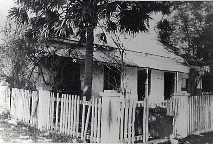
Image: Cleveland homestead, image number P10859.
The landscape of Cleveland comprises “low-lying, mostly cleared, alluvial lowlands and floodplain” adjacent to Mullet Creek and its tributaries, together with “undulating midland valley and rural landscape with irregular stands of forest vegetation surrounding homesteads, along drainage lines and upon low knolls” (Wollongong City Council, 1995, p. 27).
Open in character, the area is regarded “generally of low conservation significance due to extensive previous clearing for agricultural purposes” and is mostly geotechnically “stable” (Forbes Rigby, 1999, p.5-6).
Topography varies from an elevation of “2 - 30 metres AHD with low-lying wetlands along the eastern areas of the creeks” (Wollongong City Council, 1995, p. 27).
Rural properties used for agistment of stock, fodder production, and related activities occupy the area which is traversed by major power transmission lines, the pylons of which dominate the skyline below the nearby Illawarra escarpment.
| Date | Event |
|---|---|
| 1817 | Land grant of 300 acres made to Colonel George Molle by Governor Macquarie |
| 1833 | Land grant of 600 acres promised to George William Paul, and promptly sold |
| 1837 | Land grant of 300 acres made to E.R. Stack |
| 1839 | Land grant of 200 acres made to James Blanch |
| 1841 | Cleveland homestead built, reputedly by Maurice Fitzgerald |
| 1842 | Alleys Line of Road publicly promoted as an overland route from Dapto to Bong Bong, near Moss Vale |
| 1861 | Plan submitted for construction of road, subsequently entitled Cleveland Road, from Dapto Post Office to Rudd property. |
| 1887 | Dapto station opened as part of the Wollongong to North Kiama railway |
| 1895 | Illawarra Harbour and Land Corporation Railway built |
| 1975 | Wollongong City Council designs brief for study of West Dapto, which encompasses Cleveland, as area with potential for urban expansion of Wollongong |
| 1980 | Cleveland homestead officially registered in the Register of the National Estate |
| 1982 | Ultimately unsuccessful submission made to NSW Government by Wollongong City Council to undertake local environmental study to enable the development of West Dapto |
| 1987 | Wollongong City Council exhibits draft strategic plan for West Dapto development |
| 1987 | Wollongong City Council resolves to include Cleveland homestead on its heritage list |
| 1989 | Wollongong City Council releases Local Environmental Study for West Dapto Stage One |
| 1992 | Wollongong City Council purchases Bridgewater property on Cleveland Road for future residential development |
| 1993 | Cleveland first proposed as name for suburb in April |
| 1996 | Intergovernmental West Dapto Task Force formed to examine environmental and funding issues for future development |
| 1999 | NSW Government accepts recommendations of West Dapto Task Force for future development |
| 2004 | Wollongong City Council approaches State Government to accelerate planning of West Dapto expansion |
| 2005 | Cleveland officially gazetted as the name for the suburb in August |
| 2006 | Wollongong City Council resolves to publicly exhibit master plan for West Dapto development which includes Cleveland (April) |
Ali, Anne C., Gazetteer of historic buildings, places and relics; Wollongong, Shellharbour, Kiama and Shoalhaven, [Wollongong, NSW]: A.C. Ali, 1980.
Archives Authority of New South Wales, Index to the papers of the New South Wales Colonial Secretary 1788-1825 [microform], Sydney: Archives Authority of New South Wales, 1989.
Cousins, Arthur, The Garden of New South Wales: a history of the Illawarra & Shoalhaven Districts 1770-1900, Wollongong, NSW: Illawarra Historical Society, 1994.
Forbes Rigby Pty Ltd, Environmental impact assessment, Fowlers Road, West Dapto, Wollongong: Forbes Rigby, 1999.
Geographical Names Board of New South Wales. Geographical names register extract, Cleveland. Bathurst, NSW, The Board. Available from: http://www.gnb.nsw.gov.au/name_search/extract?id=KWQllMqbMa [Accessed 18 April 2006], 2006.
Illawarra Historical Society, Illawarra Historical Society Bulletin, Wollongong, NSW: Illawarra Historical Society, 1945+
Illawarra Mercury, Wollongong, NSW: Illawarra Newspapers Holdings, 1856-
Lindsay, Benjamin, A story of early land settlement in Illawarra: with illustrative map. The author, 1934.
McCaffrey, Frank, The history of Illawarra and its pioneers, Haberfield, NSW: Frank McCaffrey, 1922.
McDonald William Graham, Nineteenth Century Dapto: notes on the history of Dapto and its neighbourhood, Wollongong, NSW: Illawarra Historical Society, 1976.
NSW Heritage Office, Heritage Office Website. [Accessed 5 May 2006], 2006.
O’Malley, J.P., The Old Dapto Smelting Works: an address given by Rev. Bro. J.P. O’Malley to members of the Illawarra Historical Society, 2nd ed. Wollongong, NSW: Illawarra Historical Society, 1968.
Wollongong (NSW) Council. Planning and Development Dept., West Dapto: draft strategic plan, Wollongong: Wollongong City Council, 1987.
Wollongong (NSW) Council. Planning Division, The development of West Dapto: briefing notes for the Minister for Urban Affairs and Planning: for Hon. C. Knowles MP, 29 June 1995, Wollongong: Wollongong City Council, 1995.
Wollongong (NSW) Council. Strategic Planning Section, Local environmental study: West Dapto Stage One release, Bong Bong Rd, Wollongong: Wollongong City Council, 1989.
Wollongong (NSW) Council. Town planning Dept., An environmental study of the existing urban area of Dapto: carried out on behalf of the Council of the City of Wollongong, Wollongong, NSW: Wollongong City Council, 1978.
Top image: Cleveland homestead on Cleveland Road, ca. 1981. See image details on our catalogue.