Parish: Kembla
County: Camden
Cordeaux Heights is south west of Wollongong, on the lower slopes of Mount Kembla. The western part of the suburb is on the Illawarra escarpment.
Local communities of Aboriginal people were the original inhabitants and Traditional Custodians of Illawarra Land. Their dialect is a variant of the Dharawal language.
Before European settlement, the Aboriginal people of the region lived in small family groups with complicated social structures and close associations with specific areas.
Suburb boundaries do not reflect the cultural boundaries of the local Aboriginal community.
Traditional Custodians today are descendants of the original inhabitants and have ongoing spiritual and cultural ties to the Land and waterways where their ancestors lived.
Cordeaux
Cordeaux Heights
The area of Cordeaux was named after William Cordeaux (1792-1839), an early resident and land commissioner.
Cordeaux Heights is a planned suburb of Wollongong, established in the 1980s.
Land Grants
The area was first settled by Martin Robert Cole (Captain Cole), George Waples, John Graham, Robert Jenkins, Jemima Jenkins and George Lindsay, among others. For more information on Land Grants in this area, see the Farmborough Heights, Mount Kembla and Unanderra pages.
Fishlock family
The Fishlocks came to Australia in 1844. They lived in the Dapto area at Evans Farm and later purchased a block of land, Lot 73, at Cordeaux River. Robert Fishlock and his sons cleared the land and erected a building on the bank of Young's Creek. They also had stock yards and a small orchard. The Fishlocks produced honey and also supplied bark sheets for roofing (McNamara, 2007).
Carr Family
Peter Carr came to Australia in 1856. He purchased a property at Cordeaux River and called it "Avoca Vale". At the time of the Landholders' census in 1885 Peter Carr owned 261 acres and had four horses, 70 cattle and 20 pigs. Peter left the Cordeaux property around 1890 when he purchased a property known as 'Berkeley' in Unanderra (McNamara, 2007).
William Rann
Will Rann was a highly respected resident of Cordeaux. He leased property to South Coast graziers and dairymen. Rann's property was acquired by the Metropolitan Water, Sewerage and Drainage Board in 1950 (McNamara, 1997).
Dairy and general farming
For more information on early farming and dairy farming in the area, see the Farmborough Heights and Kembla Grange pages.
The Pioneer Kerosene Mine
For more information on the Pioneer Kerosene Mine, see the Mount Kembla page.
Coal mining
For more information on coal mining in this area, see the Mount Kembla page.
For more information on early transport in this area see the Unanderra, Mount Kembla and Kembla Grange pages.
The Elms
The Elms was the homestead of William and Sarah Rann, who were early settlers at Cordeaux. It was probably situated on a block of land - Lot 218 - selected by Timothy Brian. This was the first land purchased by William Rann when he arrived at Cordeaux (McNamara, 1997).
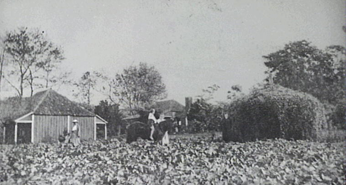
Image: The Elms, image number P13037.
The land of Cordeaux Heights forms part of the Sydney Basin. The area in general is located on a sloping topography overlying horizontal sedimentary strata on a volcanic base, known as the Illawarra Coal Measures, with residual soil and rock debris which is essentially clayey.
Cordeaux Heights varies from gently to steeply sloping and is now mainly residential, but before this the area was extensively cleared for farming purposes. Originally, the area was covered with rainforest, with abundant native flora and fauna, and there were two types of vegetation; sclerophyll forests and rainforest, which can still be found in protected gullies between foothills, along the slopes. In more open areas which have more exposure to sun and wind, Eucalypts dominate, especially Eucalyptus quadrangulata. Warm temperate and sub-tropical rainforest once grew along the banks of Charcoal Creek and rainforest merged into tall eucalypt open forest which replaced it along the ridges (Davis, 1995; Golder Moss Associates, 1974; Kembla Green Corridor, 1991).
Black Wattles predominated in the creek areas at the time of proposed feasibility studies for the establishment of the suburb, with small stands of Melaleucas, Eucalypts, and Myrtles. Almost all of the land has views of the escarpment with Mount Kembla predominating. The ridge along Staff Road protects much of the area from the colder southerly winds which prevail in winter.
Development of Cordeaux Heights
Up to 1973, the area which today is the site of Cordeaux Heights was made up of three dairy farms and had been grazed extensively. At this time the farms were purchased by R. W. Sheargold Pty. Ltd. for the potential development of a new suburb (R.W. Sheargold, 1974).
In 1974, a feasibility study was carried out by the company Golder, Moss Associates, Consulting Geotechnical Engineers. In April 1979 Wollongong City Council formulated a Development Strategy – Cordeaux Heights Estate, to be put to a Special Meeting of Council held on 9 April 1979. The area of land released was sufficient to provide housing and amenities for up to 5,000 people (Forbes and Associates, 1978; Dunk, K.R., 1979).
The plan was based on road and allotment layout being primarily dictated by pedestrian movement within the neighbourhood. The suburb was to include dedicated open space of not less than three hectares per 1,000 head of population, to cater for active and passive recreational activities. The developer was also required to construct a new section of road to provide access to and within the new suburb. The road layout and design was based on a hierarchical function of roads, conforming to the road strategy in the Unanderra area, with main distributors (Central Road and Cordeaux Road), and minor collector roads to service the area. Such things as bus routes, services (schools), accessibility around the suburb by both cars and pedestrians, and protection of the environment, were all factored into the development (Dunk, K.R., 1979).
| Date | Event |
|---|---|
| 1770 | Mount Kembla first sighted by Captain Cook, Wednesday 25 April |
| 1810 | Cedar getters commence felling trees in area |
| 1815 | Settlement begins in Figtree / Unanderra (Charcoal) areas |
| 1817 | Robert Jenkins receives land grant of 1,000 acres, which he names Berkeley |
| 1821 | O'Briens Road built descending over the range to the 'Fig Tree' |
| 1834 | Jemima Jenkins purchases 2,000 acres at Berkeley |
| 1840 | Presbyterian and Roman Catholic Schools established at Unanderra |
| 1844 | Farmborough House is built on land acquired by Robert Martin Cole Initially named 'Nonesuch' |
| 1855 | Nonesuch bought by John Blackman and renamed Farnborough; additions built |
| 1859 | Municipality of Wollongong declared |
| 1860 | Post Office opened at Charcoal |
| 1860 | Tannery established at Charcoal by John Richardson |
| 1873 | Survey for construction of Sydney to Illawarra railway begins |
| 1878 | Unanderra Public School is opened |
| 1878 | Central Illawarra Council transfers its operations to Charcoal |
| 1880 | Government railway line built in Illawarra |
| 1881 | Government Gazette changes the name of the local post office from Charcoal to Unanderra |
| 1882 | Mount Kembla coal mine constructs rail link to Port Kembla |
| 1887 | Butter factory is opened at Unanderra |
| 1887 | Unanderra Station Master’s residence built |
| 1888 | Unanderra Coke Works are constructed |
| 1901 | Unanderra Public Hall is opened |
| 1902 | 96 lives are lost in the Mount Kembla Mine Disaster |
| 1913 | Unanderra Butter factory burns down |
| 1913 | First motor bus used in Wollongong |
| 1926 | Steel works are established at Port Kembla |
| 1927 | Construction of Unanderra - Moss Vale railway line begins |
| 1927 | The Princes Highway is laid through Unanderra |
| 1932 | Unanderra - Moss Vale line opens |
| 1956 | Farmborough Road Primary School opens; first Principal is Mr W. A. Bayley |
| 1960s | Diesel trains replace steam engines on Illawarra line |
| 1969 | 'Kembla Park' demolished |
| 1974 | Feasibility study done on lower slopes of Mount Kembla for possible urban development (Cordeaux Heights) |
| 1975 | Farmborough Chase housing development is established |
| 1978 | Structure Plan for Cordeaux Heights compiled and published by Forbes & Assoc. Land Development Consultants |
| 1979 | Development strategy for Cordeaux Heights Estate put to Wollongong City Council based on 1974 feasibility study |
| 1979 | Farmborough Grove Retirement Village purchases 18 acres on site of 'Pea Paddock' of Kembla Park |
| 1982 | Farmborough Grove Retirement Village on Waples Road opens 14 March |
| 1986 | Wollongong Christian School opens six blocks with approx. 60 students; Principal is Mr Chris Connor |
| 1986 | Trains on Illawarra line electrified |
| 1999 | Unanderra Public School relocates from the Princes Highway to Derribong Drive, Cordeaux Heights |
| 2002 | Western Suburbs Child-care Centre officially opened in October |
| 2003 | Unanderra Public School celebrates 125 years. Innovative new school opened at Cordeaux Heights in 1999 |
| 2005 | Round House (approx 50 years old) on Cordeaux Road sold |
| 2009 | Keelong Juvenile Justice Centre closed in February |
Davis, Wayne, Environment Illawarra: initiatives, Wollongong: Keira Green Corridor Committee, 1995.
Dunn, K. R., Development strategy - Cordeaux Heights Estate: Town Planner's Report 29/3/79, Wollongong: Wollongong City Council, 1979.
English, Helen. Unanderra Community Profile. Wollongong City Council Community Services Division, 1985.
Environment Illawarra: the Keira Green Corridor, Wollongong, NSW: Wollongong City Council, 1992.
Forbes and Associates. Structure Plan for Cordeaux Heights. [Wollongong]: Forbes & Associates, [1978].
Golder Moss Associates. Report to Forbes & Assoc. on preliminary feasibility investigation and slope stability study for possible urban development. Central Kembla. NSW, The Author, 1974.
Hagan, Jim & Wells Andrew, (eds.), A History of Wollongong, Wollongong, NSW: University of Wollongong Press, 1997.
Illawarra Family History Group, Illawarra Pioneers Pre 1920, Wollongong, NSW: Illawarra Family History Group,1992.
Kembla Green Corridor Committee. The Kembla Green Corridor: overview. Wollongong City Council, 1991.
McNamara, John Leo, Life at Cordeaux River, New South Wales, Fairy Meadow, NSW: J. McNamara, c2007.
McNamara, John Leo, Memories of Cordeaux, 2nd ed., 1997.
R. W. Sheargold Pty Ltd, Proposed residential development at Central Kembla, [Wollongong]: R.W.Sheargold, 1974.
Top image: 'The Elms', Cordeaux. See image details on our catalogue