Construction is now complete on the causeway on Otford Road, with the road reopening to traffic from 4pm on Friday 17 November 2023.
The major project was wrapped up just over nine months after the causeway was damaged beyond repair during flooding in February 2023. During the declared natural disaster, huge slabs of concrete were lifted off the causeway by floodwater and moved along the road and into the Hacking River. The culverts under the road surface were also moved and broken.
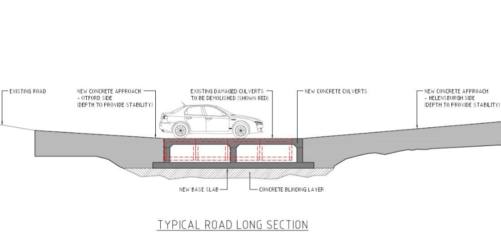
The replacement causeway has been designed to current, contemporary standards and will be able to withstand major storm events. It also has improved features including a wider deck, a central debris deflector to prevent blockages during times of significant rainfall, better line marking and additional warning signage. Below is an illustration of the replacement causeway. You can also see more detailed plans for the replacement Otford Causeway.
The previous causeway was constructed in the 1970s. The replacement causeway has been built to current engineering standards, and we have considered the latest flood and debris movement data and information when preparing the new design. This is expected to make it more robust in rain events.
We have also made a commitment to local residents to continue looking into designing flood gates on either side of the causeway to manage risk to drivers in time of flood.
Why a causeway and not a bridge?
We know there have been questions about why Council will not build a bridge at this point in Otford Road.
Council did investigate a bridge option in 2020. However, the geology, topography and landscape at this location, as well as the impact on residents and private property, means a bridge would not feasible at this location.
The 2020 investigation considered a detailed survey of the area, flood modelling which used confirmed historical flood data, and the Australian Standards for bridge design. This work showed that a bridge span of approximately 90m would be required at this location to provide safe access in major flood events. This is because a combination of flood modelling, historical information, rainfall records and observation show that floodwaters can reach a depth greater than 5m at this location. This is 2.8m higher than the flood levels of the February 2023 event, according to photos shared with Council by local residents.
Proudly funded by the NSW Government through the Transport for NSW Natural Disaster Recovery Fund.
- Your Council Officials
- Council Meetings
- Online Self Service
- News
- Public Notices
-
Works and Projects
- Current Works and Projects
-
Ongoing Projects
- West Dapto
- Grand Pacific Walk
- Southern Suburbs Community Centre and Library
- Helensburgh Community Centre and Library
- Revitalising Port Kembla
- Port Kembla Copper Project
- Windang Foreshore Improvements
- Art Gallery and Town Hall Building Works
- Vera and Wilson Streets Helensburgh
- Tunnel Road Helensburgh
- Former Helensburgh Waste Depot
- Whytes Gully Landfill
- Harry Graham Drive
- North Wollongong Surf Club and Seawall
- Recent Projects
- Future Works and Projects
- Roadworks
- Blitz Program
- Tenders, Quotations and EOIs
- Sustainability at Council
- Projects Open for Feedback
-
Access to Information
- Agency Information Guide
-
Information Registers
- Contracts Register
- Council Position Statements Register
- Council Resolutions
- Council Voting Register
- Councillor Requests for Information Relating to Business Papers
- Current Leases and Licences
- Data Breach Public Notification Register
- Delegations Register
- Designated Officers
- Development Application Register
- Development Approvals
- Development Contributions Register
- Disclosure Log
- Graffiti Removal Register
- Investments Register
- Land Register
- Parking Fines Register
- Planning Agreements Register
- Tree Removal Register
- Political Donations and Gifts
- Variation to Development Standards Register
- Council Documents
- Jobs at Council
- Tenders, Quotations and EOIs
- Corporate Governance
-
Committees and Groups
- Aboriginal Reference Group
- Audit, Risk and Improvement Committee
- City of Wollongong Awards Committee
- Floodplain Committees
- Lake Illawarra CMP Implementation Group
- Public Art Advisory Panel
- Sports and Facilities Reference Group
- Traffic Committee
- Walking, Cycling and Mobility Reference Group
- West Dapto Review Committee
- Wollongong Heritage Reference Group
- Southern Regional Planning Panel
- Wollongong Local Planning Panel
- Emergency Management